IMAGES TAKEN NEAR TO
Payhembury, HONITON, EX14 3JN
Introduction
This page details the photographs taken nearby to EX14 3JN by members of the Geograph project.
The Geograph project started in 2005 with the aim of publishing, organising and preserving representative images for every square kilometre of Great Britain, Ireland and the Isle of Man.

There are currently over 7.5m images from over14,400 individuals and you can help contribute to the project by visiting https://www.geograph.org.uk
Image Map
Images are licensed for reuse under creativecommons.org/licenses/by-sa/2.0
Notes
- Clicking on the map will re-center to the selected point.
- The higher the marker number, the further away the image location is from the centre of the postcode.
Image Listing (6 Images Found)
Images are licensed for reuse under creativecommons.org/licenses/by-sa/2.0
Image
Details
Distance
2
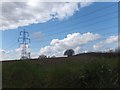
Pylon and trees silhouetted above a ploughed field
Image: © David Smith
Taken: 12 Apr 2013
0.18 miles
5
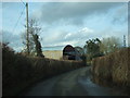
Barns at Shoots Barn Cross outside Colestocks
Image: © David Smith
Taken: 3 Feb 2011
0.19 miles
6
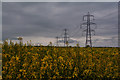
East Devon : Rapeseed
Looking across a field of rapeseed in the countryside.
Image: © Lewis Clarke
Taken: 9 May 2018
0.25 miles