IMAGES TAKEN NEAR TO
Payhembury, HONITON, EX14 3HY
Introduction
This page details the photographs taken nearby to EX14 3HY by members of the Geograph project.
The Geograph project started in 2005 with the aim of publishing, organising and preserving representative images for every square kilometre of Great Britain, Ireland and the Isle of Man.

There are currently over 7.5m images from over14,400 individuals and you can help contribute to the project by visiting https://www.geograph.org.uk
Image Map
Images are licensed for reuse under creativecommons.org/licenses/by-sa/2.0
Notes
- Clicking on the map will re-center to the selected point.
- The higher the marker number, the further away the image location is from the centre of the postcode.
Image Listing (19 Images Found)
Images are licensed for reuse under creativecommons.org/licenses/by-sa/2.0
Image
Details
Distance
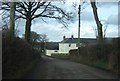
1
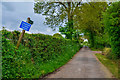
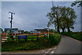
East Devon : Country Lane
A small lane heading through the countryside.
Image: © Lewis Clarke
Taken: 9 May 2018
0.01 miles
2
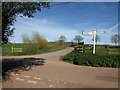
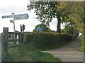
Haskins Cross
Looking in the opposite direction to Image from the end of the green lane from Tale Head Cross.
Image: © Derek Harper
Taken: 6 Apr 2011
0.02 miles
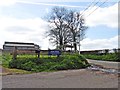
4
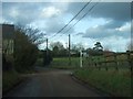
Haskins cross, on the edge of Payhembury
Sign says "R.J. Leach & Son (milling) Weighbridge & Mill offices"
Image: © Rob Purvis
Taken: 9 Mar 2013
0.03 miles
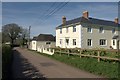
5
East Devon : Barrow Road
Looking along Barrow Road as it heads into Payhembury.
Image: © Lewis Clarke
Taken: 9 May 2018
0.03 miles
6
Road unsuitable for motor vehicles at Haskins Cross
Image: © Sarah Charlesworth
Taken: 30 Oct 2010
0.03 miles
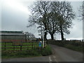
8
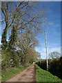
Approaching Haskins Cross
East of the Pound House, where it takes on the role of entrance drive, the green lane shown in Image is tarmaced.
Image: © Derek Harper
Taken: 6 Apr 2011
0.04 miles
10
Victoria Dairy Farm
The farmhouse and one of the outbuildings, on Barrow Road, between Payhembury and Haskins Cross
Image: © Derek Harper
Taken: 6 Apr 2011
0.08 miles