IMAGES TAKEN NEAR TO
Barton Rise, HONITON, EX14 3HW
Introduction
This page details the photographs taken nearby to Barton Rise, EX14 3HW by members of the Geograph project.
The Geograph project started in 2005 with the aim of publishing, organising and preserving representative images for every square kilometre of Great Britain, Ireland and the Isle of Man.

There are currently over 7.5m images from over14,400 individuals and you can help contribute to the project by visiting https://www.geograph.org.uk
Image Map
Images are licensed for reuse under creativecommons.org/licenses/by-sa/2.0
Notes
- Clicking on the map will re-center to the selected point.
- The higher the marker number, the further away the image location is from the centre of the postcode.
Image Listing (50 Images Found)
Images are licensed for reuse under creativecommons.org/licenses/by-sa/2.0
Image
Details
Distance
1
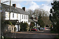
Feniton: the old village centre
A post office and the church provide the focus here, the latter hidden from the main street
Image: © Martin Bodman
Taken: 1 Mar 2006
0.03 miles
3
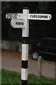
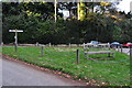
Old Direction Sign - Signpost in Feniton, Feniton Parish
No finial - 3 arms; by the UC road, in parish of Feniton (East Devon District), at the junction of Curscombe Lane, Broad Road and Green Lane, on grass triangle.
To be surveyed
Milestone Society National ID: DV_SY1099
Image: © Milestone Society
Taken: Unknown
0.05 miles

5
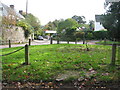
Bench on the triangular green at the centre of Feniton Court
Image: © Sarah Charlesworth
Taken: 30 Oct 2010
0.05 miles
6
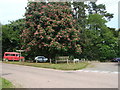
Chestnut tree at the junction, Feniton
Update e-mailed Dec 2009 from Paul Livsey (many thanks Paul):
"The tree was planted in 1903 Unfortunately probably one of the last photos of the tree in bloom as the tree was diseased and was cut down in October. There now lies a pile of sawdust! I believe some cuttings were taken from the tree and a healthy one will be planted at a later stage."
Image: © Ruth Sharville
Taken: 25 May 2009
0.05 miles
7
Feniton : Feniton Green
A village green acts as a road junction between Broad Road and Curscombe Lane.
Image: © Lewis Clarke
Taken: 28 Nov 2010
0.05 miles
8
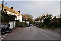
Feniton : Broad Road
One of the main roads through this side of the village. It heads down towards the A38 and Fenny Bridges.
Image: © Lewis Clarke
Taken: 28 Nov 2010
0.05 miles
9
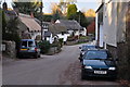
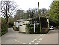
Feniton : Curscombe Lane
A scenic road (albeit with several cars) with cottages which have thatched roofs.
Image: © Lewis Clarke
Taken: 28 Nov 2010
0.06 miles
