IMAGES TAKEN NEAR TO
Payhembury, HONITON, EX14 3HL
Introduction
This page details the photographs taken nearby to EX14 3HL by members of the Geograph project.
The Geograph project started in 2005 with the aim of publishing, organising and preserving representative images for every square kilometre of Great Britain, Ireland and the Isle of Man.

There are currently over 7.5m images from over14,400 individuals and you can help contribute to the project by visiting https://www.geograph.org.uk
Image Map
Images are licensed for reuse under creativecommons.org/licenses/by-sa/2.0
Notes
- Clicking on the map will re-center to the selected point.
- The higher the marker number, the further away the image location is from the centre of the postcode.
Image Listing (29 Images Found)
Images are licensed for reuse under creativecommons.org/licenses/by-sa/2.0
Image
Details
Distance
1

Richard's Farm
Outbuildings by the C16 farmhouse, at the hamlet glimpsed in Image
Image: © Derek Harper
Taken: 6 Apr 2011
0.02 miles
2
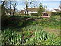
Lower Tale Cottage
The C17 thatched cottage http://www.britishlistedbuildings.co.uk/en-86854-lower-tale-cottage-payhembury is seen across a pond that could be an early manifestation of the River Clyst.
Image: © Derek Harper
Taken: 6 Apr 2011
0.04 miles
3
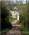
Lower Tale
The lane from Higher Tale drops into the hamlet, which clusters around a headwater of the Clyst. The first building on the right is part of Richard's Farm.
Image: © Derek Harper
Taken: 6 Apr 2011
0.04 miles
4

Shed, Higher Tale
A corrugated iron shed in a field beside the lane to Lower Tale.
Image: © Derek Harper
Taken: 6 Apr 2011
0.09 miles

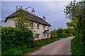
6
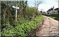
Signpost, Higher Tale
Most junctions in these parts have names but this one, disappointingly, doesn't seem to - nothing on the maps or the signpost itself. On the right is the thatched Tale House Cottage.
Image: © Derek Harper
Taken: 6 Apr 2011
0.19 miles
7
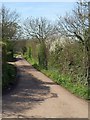
Lane to Clyst Hydon
The lane from Higher Tale leaves the junction shown in Image, heading gently downhill towards the Clyst valley.
Image: © Derek Harper
Taken: 6 Apr 2011
0.19 miles
8
Higher Tale : Country Lane
A country lane heading alongside Tale House Cottage.
Image: © Lewis Clarke
Taken: 3 May 2018
0.21 miles
9

East Devon : Tale Lane
Looking along Tale Lane in East Devon.
Image: © Lewis Clarke
Taken: 3 May 2018
0.21 miles
10

Cottage, Higher Tale
Looking past the thatched Farthings along the lane into the hamlet.
Image: © Derek Harper
Taken: 6 Apr 2011
0.22 miles