IMAGES TAKEN NEAR TO
Payhembury, HONITON, EX14 3HD
Introduction
This page details the photographs taken nearby to EX14 3HD by members of the Geograph project.
The Geograph project started in 2005 with the aim of publishing, organising and preserving representative images for every square kilometre of Great Britain, Ireland and the Isle of Man.

There are currently over 7.5m images from over14,400 individuals and you can help contribute to the project by visiting https://www.geograph.org.uk
Image Map
Images are licensed for reuse under creativecommons.org/licenses/by-sa/2.0
Notes
- Clicking on the map will re-center to the selected point.
- The higher the marker number, the further away the image location is from the centre of the postcode.
Image Listing (28 Images Found)
Images are licensed for reuse under creativecommons.org/licenses/by-sa/2.0
Image
Details
Distance
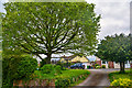
4

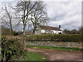
Looking north from Payhembury Cross, in Payhembury
Image: © Rob Purvis
Taken: 21 Apr 2013
0.12 miles
5
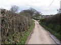
Payhembury : Barrow Road
Barrow Road heading into the village.
Image: © Lewis Clarke
Taken: 9 May 2018
0.12 miles
6
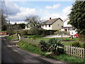
Payhembury : Berkleigh
A driveway up to Berkleigh on Barrow Road.
Image: © Lewis Clarke
Taken: 9 May 2018
0.13 miles
7

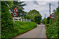
Road signs at Payhembury Cross, in Payhembury
Image: © Rob Purvis
Taken: 21 Apr 2013
0.13 miles
8
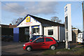
Payhembury: Alan?s Motors
Near the western end of the village. Looking north east
Image: © Martin Bodman
Taken: 6 Mar 2006
0.13 miles
9
Payhembury : Barrow Road
Looking along Barrow Road heading through Payhembury.
Image: © Lewis Clarke
Taken: 9 May 2018
0.14 miles
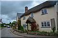
10

Junction, Payhembury
Barrow Road arrives at a T-junction in the centre of the village.
Image: © Derek Harper
Taken: 6 Apr 2011
0.15 miles