IMAGES TAKEN NEAR TO
Buckerell, HONITON, EX14 3ET
Introduction
This page details the photographs taken nearby to EX14 3ET by members of the Geograph project.
The Geograph project started in 2005 with the aim of publishing, organising and preserving representative images for every square kilometre of Great Britain, Ireland and the Isle of Man.

There are currently over 7.5m images from over14,400 individuals and you can help contribute to the project by visiting https://www.geograph.org.uk
Image Map
Images are licensed for reuse under creativecommons.org/licenses/by-sa/2.0
Notes
- Clicking on the map will re-center to the selected point.
- The higher the marker number, the further away the image location is from the centre of the postcode.
Image Listing (8 Images Found)
Images are licensed for reuse under creativecommons.org/licenses/by-sa/2.0
Image
Details
Distance
1
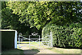
Buckerell: The Lodge
Probably an original entrance to Hembury Fort House but now to the Lodge, a private residence. Looking north west
Image: © Martin Bodman
Taken: 24 Jun 2006
0.01 miles
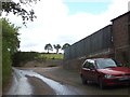
2
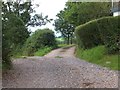
Tracks to Combehayes Farm
Both of these roads give access to the farm
Image: © David Smith
Taken: 20 Aug 2012
0.01 miles

4
The road that passes Combehayes Farm
Image: © Sarah Charlesworth
Taken: 30 Oct 2010
0.08 miles
5

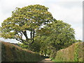
Lane north of Summerhayes Farm
Further along the lane shown in Image, with an oak overhanging. The lane is running along the western slopes of Buckerell Knap.
Image: © Derek Harper
Taken: 26 Jan 2012
0.13 miles
6

Lane to the A373
The next oak tree along the lane is in square, but the double bend beyond is in Image, while New Park Farm on the left is in Image The wooded hillside is near Wolverstone.
Image: © Derek Harper
Taken: 26 Jan 2012
0.20 miles
7
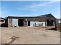
The working area of Summerhayes farm
The entrance to the farm yard is above the farm buildings on the right
Image: © David Smith
Taken: 20 Aug 2012
0.24 miles