IMAGES TAKEN NEAR TO
Buckerell, HONITON, EX14 3EH
Introduction
This page details the photographs taken nearby to EX14 3EH by members of the Geograph project.
The Geograph project started in 2005 with the aim of publishing, organising and preserving representative images for every square kilometre of Great Britain, Ireland and the Isle of Man.

There are currently over 7.5m images from over14,400 individuals and you can help contribute to the project by visiting https://www.geograph.org.uk
Image Map
Images are licensed for reuse under creativecommons.org/licenses/by-sa/2.0
Notes
- Clicking on the map will re-center to the selected point.
- The higher the marker number, the further away the image location is from the centre of the postcode.
Image Listing (8 Images Found)
Images are licensed for reuse under creativecommons.org/licenses/by-sa/2.0
Image
Details
Distance
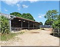
3

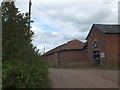
Farm buildings at Sowton
A little up the lane from Image, seen about half an hour before sunset on the longest day of the year.
Image: © Derek Harper
Taken: 21 Jun 2006
0.05 miles
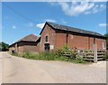
4
Sowton Farm, Feniton
On the lane between Fenny Bridges and Buckerell.
Image: © Derek Harper
Taken: 21 Jun 2006
0.06 miles
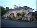
5
Farm buildings, Sowton Farm, Feniton
Taken from a short but curious footpath between Feniton and Sowton.
Image: © Derek Harper
Taken: 21 Jun 2006
0.08 miles
7
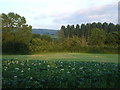
Potato patch at Sowton Farm
View from the lane at Sowton Farm near Feniton across the Otter valley.
Image: © Derek Harper
Taken: 21 Jun 2006
0.13 miles
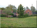
8
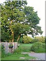
Gate and field, Sowton
By the lane between Buckerell Cross and Sowton, at Prince James Lodge.
Image: © Derek Harper
Taken: 21 Jun 2006
0.22 miles