IMAGES TAKEN NEAR TO
Mount View, HONITON, EX14 3EB
Introduction
This page details the photographs taken nearby to Mount View, EX14 3EB by members of the Geograph project.
The Geograph project started in 2005 with the aim of publishing, organising and preserving representative images for every square kilometre of Great Britain, Ireland and the Isle of Man.

There are currently over 7.5m images from over14,400 individuals and you can help contribute to the project by visiting https://www.geograph.org.uk
Image Map
Images are licensed for reuse under creativecommons.org/licenses/by-sa/2.0
Notes
- Clicking on the map will re-center to the selected point.
- The higher the marker number, the further away the image location is from the centre of the postcode.
Image Listing (6 Images Found)
Images are licensed for reuse under creativecommons.org/licenses/by-sa/2.0
Image
Details
Distance
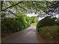
2
Road in a Village
Looking south along Acland Park road in the village of Feniton, Devon.
Image: © John P Reeves
Taken: 2 Aug 2022
0.10 miles
3
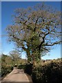
Lane from Feniton to Feniton
The lane between the newer, larger village near the station and the old village on the hill around the church passes oak trees.
Image: © Derek Harper
Taken: 6 Apr 2011
0.16 miles
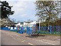
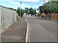
4

Terraced houses on Station Road, Feniton
Image: © Roger Cornfoot
Taken: 5 Apr 2017
0.17 miles