IMAGES TAKEN NEAR TO
Feniton, HONITON, EX14 3DA
Introduction
This page details the photographs taken nearby to EX14 3DA by members of the Geograph project.
The Geograph project started in 2005 with the aim of publishing, organising and preserving representative images for every square kilometre of Great Britain, Ireland and the Isle of Man.

There are currently over 7.5m images from over14,400 individuals and you can help contribute to the project by visiting https://www.geograph.org.uk
Image Map
Images are licensed for reuse under creativecommons.org/licenses/by-sa/2.0
Notes
- Clicking on the map will re-center to the selected point.
- The higher the marker number, the further away the image location is from the centre of the postcode.
Image Listing (6 Images Found)
Images are licensed for reuse under creativecommons.org/licenses/by-sa/2.0
Image
Details
Distance
1
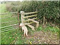
Stile on a Public Footpath
A wooden stile on the public footpath between Long Park and Higher Colesworthy near Feniton in Devon.
Image: © John P Reeves
Taken: 15 Nov 2021
0.09 miles
2
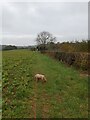
Footpath on the Edge of a Field
On a public footpath at the edge of field between Long Park and Higher Colesworthy near Feniton in Devon.
Image: © John P Reeves
Taken: 15 Nov 2021
0.10 miles
3
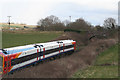
Feniton: Exeter ? Salisbury line
A London-bound train heading east, having just passed under bridge E4/491, as designated by Railtrack
Image: © Martin Bodman
Taken: 1 Mar 2006
0.17 miles
4
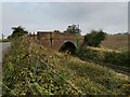
Road Bridge over the Railway
A view of the road bridge over the railway on the country road between Feniton and Talewater in Devon. The railway that it crosses is the Great Western Railway line that runs between Exeter and Honiton.
Image: © John P Reeves
Taken: 15 Nov 2021
0.17 miles

6

Feniton: railway between Feniton and Talaton
Looking towards Exeter from bridge E4/491. The line here used to be double track
Image: © Martin Bodman
Taken: 1 Mar 2006
0.19 miles