IMAGES TAKEN NEAR TO
Green Lane, HONITON, EX14 3BP
Introduction
This page details the photographs taken nearby to Green Lane, EX14 3BP by members of the Geograph project.
The Geograph project started in 2005 with the aim of publishing, organising and preserving representative images for every square kilometre of Great Britain, Ireland and the Isle of Man.

There are currently over 7.5m images from over14,400 individuals and you can help contribute to the project by visiting https://www.geograph.org.uk
Image Map
Images are licensed for reuse under creativecommons.org/licenses/by-sa/2.0
Notes
- Clicking on the map will re-center to the selected point.
- The higher the marker number, the further away the image location is from the centre of the postcode.
Image Listing (18 Images Found)
Images are licensed for reuse under creativecommons.org/licenses/by-sa/2.0
Image
Details
Distance
1
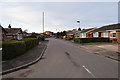
Feniton : Wells Avenue
Wells Avenue off of Green Lane in the East Devon town of Feniton.
Image: © Lewis Clarke
Taken: 28 Nov 2010
0.03 miles
2
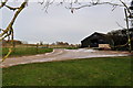
Feniton : Feniton Farm Building
A driveway to the farm building and barn taken from a nearby footpath.
Image: © Lewis Clarke
Taken: 28 Nov 2010
0.07 miles
3
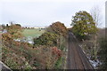
Feniton : Railway Line & Countryside
The railway heads out towards the countryside from Feniton.
Image: © Lewis Clarke
Taken: 28 Nov 2010
0.09 miles
4
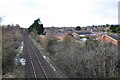
Feniton : Railway Line
The Railway Line from London Waterloo to Exeter heading through Feniton.
Image: © Lewis Clarke
Taken: 28 Nov 2010
0.09 miles
5
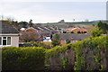
Feniton : Rooftops from Green Lane
Looking down into the gardens and up towards the rooftops of Feniton.
Image: © Lewis Clarke
Taken: 28 Nov 2010
0.13 miles
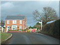
6
Road narrows as it leaves Feniton
Image: © Sarah Charlesworth
Taken: 30 Oct 2010
0.15 miles
7

Feniton : Dog Training Centre
Looks to me like an assault course for canines. This was taken from the footpath.
Image: © Lewis Clarke
Taken: 28 Nov 2010
0.18 miles
8

Feniton : Greenacres Close
Greenacres Close just off of Green Lane is a small cul-de-sac.
Image: © Lewis Clarke
Taken: 28 Nov 2010
0.20 miles
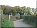
9
Ottery Road and Green Lane, Feniton
Ottery Road was closed and all traffic was diverted to the left and through the centre of Feniton
Image: © David Smith
Taken: 3 Feb 2011
0.21 miles
10
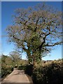
Lane from Feniton to Feniton
The lane between the newer, larger village near the station and the old village on the hill around the church passes oak trees.
Image: © Derek Harper
Taken: 6 Apr 2011
0.21 miles