IMAGES TAKEN NEAR TO
Nags Head Road, HONITON, EX14 3AP
Introduction
This page details the photographs taken nearby to Nags Head Road, EX14 3AP by members of the Geograph project.
The Geograph project started in 2005 with the aim of publishing, organising and preserving representative images for every square kilometre of Great Britain, Ireland and the Isle of Man.

There are currently over 7.5m images from over14,400 individuals and you can help contribute to the project by visiting https://www.geograph.org.uk
Image Map
Images are licensed for reuse under creativecommons.org/licenses/by-sa/2.0
Notes
- Clicking on the map will re-center to the selected point.
- The higher the marker number, the further away the image location is from the centre of the postcode.
Image Listing (49 Images Found)
Images are licensed for reuse under creativecommons.org/licenses/by-sa/2.0
Image
Details
Distance
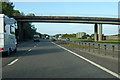
1
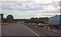
A30 one third of a mile from A375 Honiton exit
Image: © Julian P Guffogg
Taken: 12 Aug 2013
0.03 miles

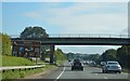
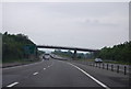
6
A30 heading west
Hayne Lane crosses the bridge.
Image: © Robin Webster
Taken: 7 Sep 2019
0.04 miles
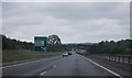
8

Old A30 on the outskirts of Honiton
The old road runs parallel to the new road (beyond the fence). This overbridge crosses both roads.
Image: © Sarah Charlesworth
Taken: 14 Dec 2009
0.05 miles
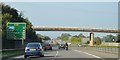
9

Honiton : The A30
Looking down to the A30 at around 8:47pm.
Image: © Lewis Clarke
Taken: 8 Apr 2018
0.05 miles
10
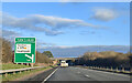
On the A30 heading east, approaching the Honiton turning
Image: © Rob Purvis
Taken: 5 Dec 2021
0.06 miles