IMAGES TAKEN NEAR TO
Holly Close, HONITON, EX14 2XY
Introduction
This page details the photographs taken nearby to Holly Close, EX14 2XY by members of the Geograph project.
The Geograph project started in 2005 with the aim of publishing, organising and preserving representative images for every square kilometre of Great Britain, Ireland and the Isle of Man.

There are currently over 7.5m images from over14,400 individuals and you can help contribute to the project by visiting https://www.geograph.org.uk
Image Map
Images are licensed for reuse under creativecommons.org/licenses/by-sa/2.0
Notes
- Clicking on the map will re-center to the selected point.
- The higher the marker number, the further away the image location is from the centre of the postcode.
Image Listing (31 Images Found)
Images are licensed for reuse under creativecommons.org/licenses/by-sa/2.0
Image
Details
Distance
1
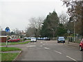
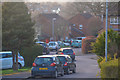
Mini roundabout outside Littletown School
Image: © Sarah Charlesworth
Taken: 14 Dec 2009
0.04 miles
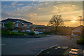
3

Honiton : Brand Road
Looking down towards Brand Road and houses.
Image: © Lewis Clarke
Taken: 8 Apr 2018
0.09 miles
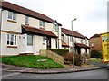
4
Honiton : Gronau Close
Looking along Gronau Close off of Weatherill Road.
Image: © Lewis Clarke
Taken: 8 Apr 2018
0.09 miles
5

Honiton : Weatherill Road
Looking along Weatherill Road in Honiton.
Image: © Lewis Clarke
Taken: 8 Apr 2018
0.13 miles
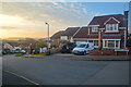
6
Honiton : Brand Close
Looking along Brand Road off of Weatherill Road.
Image: © Lewis Clarke
Taken: 8 Apr 2018
0.14 miles
7
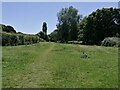
Open space by the River Gissage
This area alongside the River Gissage is a popular spot for dog walkers. The path leads to the Honiton Bottom Village Green, a public open space.
Image: © Brian Henley
Taken: 22 Jun 2022
0.15 miles
8

Fence by the River Gissage
Looking down at the Gissage from the protective fence. The stream is a long way down.
Image: © Brian Henley
Taken: 12 Jul 2020
0.15 miles
9
Honiton : Hazelwood Close
Looking off from Weatherill Road to Hazelwood Close.
Image: © Lewis Clarke
Taken: 8 Apr 2018
0.15 miles
10
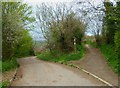
Orange Way in Devon and Torbay (417)
Here is a footpath junction on Higher Brand Lane. The footpath must be new as it is not yet marked on OS mapping.
Image: © Shazz
Taken: 16 Apr 2012
0.16 miles