IMAGES TAKEN NEAR TO
Marlpits Lane, HONITON, EX14 2NY
Introduction
This page details the photographs taken nearby to Marlpits Lane, EX14 2NY by members of the Geograph project.
The Geograph project started in 2005 with the aim of publishing, organising and preserving representative images for every square kilometre of Great Britain, Ireland and the Isle of Man.

There are currently over 7.5m images from over14,400 individuals and you can help contribute to the project by visiting https://www.geograph.org.uk
Image Map
Images are licensed for reuse under creativecommons.org/licenses/by-sa/2.0
Notes
- Clicking on the map will re-center to the selected point.
- The higher the marker number, the further away the image location is from the centre of the postcode.
Image Listing (135 Images Found)
Images are licensed for reuse under creativecommons.org/licenses/by-sa/2.0
Image
Details
Distance
1
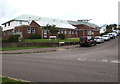
Honiton Surgery, Honiton
The Haydons Park side of the medical surgery on the corner of Marlpits Lane.
Image: © Jaggery
Taken: 1 Aug 2017
0.02 miles
2
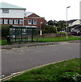
Marlpits Lane bus stop and shelter, Honiton
Between Crosscut Way and Haydons Park, near the entrance http://www.geograph.org.uk/photo/5602131 to Honiton Community Hospital.
Image: © Jaggery
Taken: 1 Aug 2017
0.02 miles
3
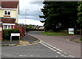
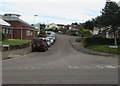
Junction of Crosscut Way and Marlpits Lane, Honiton
Crosscut Way from the left joins Marlpits Lane.
The entrance http://www.geograph.org.uk/photo/5602131 to Honiton Community Hospital is on the right.
Image: © Jaggery
Taken: 1 Aug 2017
0.02 miles
4
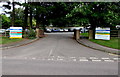
Entrance to Honiton Community Hospital, Honiton
From the east side of Marlpits Lane.
Image: © Jaggery
Taken: 1 Aug 2017
0.03 miles
5
Haydons Park, Honiton
The road named Haydons Park viewed across Marlpits Lane. Honiton Surgery http://www.geograph.org.uk/photo/5484465 is on the left.
Image: © Jaggery
Taken: 1 Aug 2017
0.05 miles
6
Marlpits Lane houses, Honiton
The corner of Lower Brand Lane http://www.geograph.org.uk/photo/5483641 is on the right.
Image: © Jaggery
Taken: 1 Aug 2017
0.05 miles
7
No parking in Marlpits Lane, Honiton
Double yellow lines on both sides of Marlpits Lane indicate no parking at any time.
Image: © Jaggery
Taken: 1 Aug 2017
0.05 miles
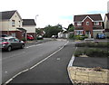
8
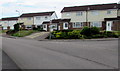
Woodmans Crescent, Honiton
Viewed from Crosscut Way on the west side of Marlpits Lane.
Image: © Jaggery
Taken: 1 Aug 2017
0.06 miles
9
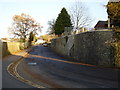
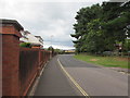
Marlpits Lane, Honiton
The wall is much older than the hospital which now stands behind it.
Image: © Anthony Vosper
Taken: 29 Nov 2010
0.07 miles
10
Crosscut Way, Honiton
On the west side of Marlpits Lane.
Image: © Jaggery
Taken: 1 Aug 2017
0.07 miles