IMAGES TAKEN NEAR TO
Pine Grove, HONITON, EX14 2HS
Introduction
This page details the photographs taken nearby to Pine Grove, EX14 2HS by members of the Geograph project.
The Geograph project started in 2005 with the aim of publishing, organising and preserving representative images for every square kilometre of Great Britain, Ireland and the Isle of Man.

There are currently over 7.5m images from over14,400 individuals and you can help contribute to the project by visiting https://www.geograph.org.uk
Image Map
Images are licensed for reuse under creativecommons.org/licenses/by-sa/2.0
Notes
- Clicking on the map will re-center to the selected point.
- The higher the marker number, the further away the image location is from the centre of the postcode.
Image Listing (202 Images Found)
Images are licensed for reuse under creativecommons.org/licenses/by-sa/2.0
Image
Details
Distance
1
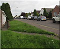
On-street parking, Orchard Way, Honiton
Orchard Way leads to Westcott Way. The path through grass leads to a row of three bungalows. http://www.geograph.org.uk/photo/5619733
Image: © Jaggery
Taken: 1 Aug 2017
0.08 miles
2
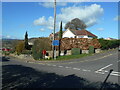
Pine grove, Honiton
A quiet post war corner of town.
Image: © Anthony Vosper
Taken: 26 Feb 2021
0.09 miles
3
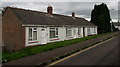
Row of three bungalows, Orchard Way, Honiton
Originally, bungalow was used in English for a lightly-built house, with a veranda and one storey.
In current UK usage it is a convenient word for any one-storey dwelling.
Image: © Jaggery
Taken: 1 Aug 2017
0.09 miles
4

Queen Elizabeth II postbox alongside a public footpath in Honiton
St Michael's Day Centre http://www.geograph.org.uk/photo/5619741 is on the left.
Image: © Jaggery
Taken: 1 Aug 2017
0.10 miles
5

Junction of Orchard Way and Queen Street, Honiton
Orchard Way is on the camera side and ahead. Queen Street on the right leads to New Street.
Image: © Jaggery
Taken: 1 Aug 2017
0.10 miles
6

Orchard Way, Honiton
The southern part of Orchard Way viewed from the corner of Queen Street.
Image: © Jaggery
Taken: 1 Aug 2017
0.12 miles
7
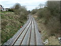
Railway from the bridge on Queen Street, Honiton
It is double track in the station but quickly reverts to single track working.
Image: © Chris Allen
Taken: 30 Mar 2013
0.12 miles
8

The Family History Shop, Honiton High Street
Family history research services are provided through this shop environment. They claim that “there is simply not another shop like it”.
It has the unusual address of 8 and a half, High Street.
Image: © Robin Drayton
Taken: 13 Sep 2015
0.13 miles
9
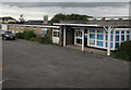
St Michael's Day Centre, Orchard Way, Honiton
A Devon County Council day centre for senior citizens.
Image: © Jaggery
Taken: 1 Aug 2017
0.13 miles
10
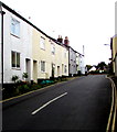
Queen Street houses, Honiton
On the north side of Queen Street on the ascent towards Orchard Way.
Image: © Jaggery
Taken: 1 Aug 2017
0.14 miles