IMAGES TAKEN NEAR TO
Ridgeway, HONITON, EX14 2GF
Introduction
This page details the photographs taken nearby to Ridgeway, EX14 2GF by members of the Geograph project.
The Geograph project started in 2005 with the aim of publishing, organising and preserving representative images for every square kilometre of Great Britain, Ireland and the Isle of Man.

There are currently over 7.5m images from over14,400 individuals and you can help contribute to the project by visiting https://www.geograph.org.uk
Image Map
Images are licensed for reuse under creativecommons.org/licenses/by-sa/2.0
Notes
- Clicking on the map will re-center to the selected point.
- The higher the marker number, the further away the image location is from the centre of the postcode.
Image Listing (15 Images Found)
Images are licensed for reuse under creativecommons.org/licenses/by-sa/2.0
Image
Details
Distance
1
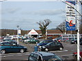
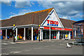
Tesco, Battishorne Way, Honiton
First opened in October 1995. Photograph taken after refit and restyle in February 2007.
Image: © Tony Tooley
Taken: 8 Mar 2007
0.14 miles
2
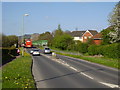
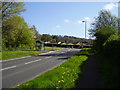
Bridges over the South West railway line
The A375 Sidmouth Road. the green structure is a pedestrian route.
Image: © Anthony Vosper
Taken: 11 Apr 2011
0.14 miles
3
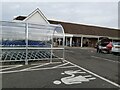
Retail Store
The Tesco shop store front as viewed from the car park in the Littletown area of Honiton in Devon.
Image: © John P Reeves
Taken: 29 Nov 2021
0.15 miles
4
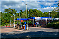
Honiton : Tesco Petrol Station
A petrol station in Honiton.
Image: © Lewis Clarke
Taken: 13 May 2018
0.15 miles
5
Honiton : Tesco
A Tesco store in Honiton.
Image: © Lewis Clarke
Taken: 13 May 2018
0.16 miles
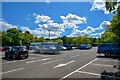
6
Tesco supermarket car park
The car park is screened from the A375 by the trees on the right. The shelters for trolleys have a wooden surround; is this supposed to make them green?
Image: © David Smith
Taken: 20 Jul 2011
0.18 miles
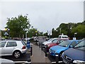
7
Honiton : Tesco Car Park
A car park beside Tesco.
Image: © Lewis Clarke
Taken: 7 May 2022
0.18 miles
8
Honiton : Battishorne Way
Looking along Battishorne Way on the roundabout.
Image: © Lewis Clarke
Taken: 13 May 2018
0.19 miles
9
Looking South up the Sidmouth Road
Mid afternoon and the road is empty. To the left is a large Tesco's store.
Image: © Anthony Vosper
Taken: 11 Apr 2011
0.19 miles
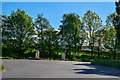
10
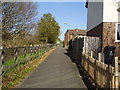
Footpath on the Heathpark Estate
To the left is the london to the south West railway line. To the right is the Heathpark estate. This was a former M.O.D site. Which was used in the 1970's to house refugees from Uganda.
Image: © Anthony Vosper
Taken: 11 Apr 2011
0.19 miles