IMAGES TAKEN NEAR TO
Upland Chase, HONITON, EX14 2FT
Introduction
This page details the photographs taken nearby to Upland Chase, EX14 2FT by members of the Geograph project.
The Geograph project started in 2005 with the aim of publishing, organising and preserving representative images for every square kilometre of Great Britain, Ireland and the Isle of Man.

There are currently over 7.5m images from over14,400 individuals and you can help contribute to the project by visiting https://www.geograph.org.uk
Image Map
Images are licensed for reuse under creativecommons.org/licenses/by-sa/2.0
Notes
- Clicking on the map will re-center to the selected point.
- The higher the marker number, the further away the image location is from the centre of the postcode.
Image Listing (6 Images Found)
Images are licensed for reuse under creativecommons.org/licenses/by-sa/2.0
Image
Details
Distance
1

Fence by the River Gissage
Looking down at the Gissage from the protective fence. The stream is a long way down.
Image: © Brian Henley
Taken: 12 Jul 2020
0.13 miles
2
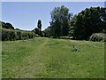
Open space by the River Gissage
This area alongside the River Gissage is a popular spot for dog walkers. The path leads to the Honiton Bottom Village Green, a public open space.
Image: © Brian Henley
Taken: 22 Jun 2022
0.14 miles
3

Dog walking area
Situated off Honiton Bottom Road.
Image: © Anthony Vosper
Taken: 29 Nov 2010
0.18 miles
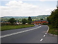
4

Bridge over the River Gissage
Battishorn Road,Honiton.
Image: © Anthony Vosper
Taken: 29 Nov 2010
0.24 miles
5
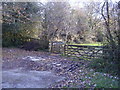
Gate and footpath on Battishorn Road
This area contains a small nature reserve.
Image: © Anthony Vosper
Taken: 29 Nov 2010
0.24 miles