IMAGES TAKEN NEAR TO
Marker Way, HONITON, EX14 2EL
Introduction
This page details the photographs taken nearby to Marker Way, EX14 2EL by members of the Geograph project.
The Geograph project started in 2005 with the aim of publishing, organising and preserving representative images for every square kilometre of Great Britain, Ireland and the Isle of Man.

There are currently over 7.5m images from over14,400 individuals and you can help contribute to the project by visiting https://www.geograph.org.uk
Image Map
Images are licensed for reuse under creativecommons.org/licenses/by-sa/2.0
Notes
- Clicking on the map will re-center to the selected point.
- The higher the marker number, the further away the image location is from the centre of the postcode.
Image Listing (21 Images Found)
Images are licensed for reuse under creativecommons.org/licenses/by-sa/2.0
Image
Details
Distance
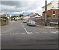
1
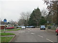
Mini roundabout outside Littletown School
Image: © Sarah Charlesworth
Taken: 14 Dec 2009
0.10 miles
2

Fence by the River Gissage
Looking down at the Gissage from the protective fence. The stream is a long way down.
Image: © Brian Henley
Taken: 12 Jul 2020
0.13 miles
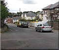
3
Littletown Rd Honiton
The photographer is in the very north east corner of the grid square and four grid squares are visible in this photo. In the left foreground is SY1699, in the right foreground is ST1600, the left background is SY1599 and the right background is ST1500.
Image: © Nigel Mykura
Taken: 13 Jul 2019
0.14 miles
4
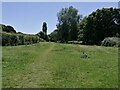
Open space by the River Gissage
This area alongside the River Gissage is a popular spot for dog walkers. The path leads to the Honiton Bottom Village Green, a public open space.
Image: © Brian Henley
Taken: 22 Jun 2022
0.16 miles
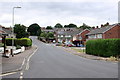
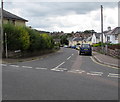
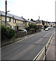
5
West down Littletown Road, Honiton
Littletown Road descends into the Littletown area of Honiton.
Image: © Jaggery
Taken: 1 Aug 2017
0.16 miles
6
Junction of Littletown Road and Streamers Meadows, Honiton
The road named Streamers Meadows heads north away from Littletown Road.
Image: © Jaggery
Taken: 1 Aug 2017
0.17 miles
7
Livermore Road, Honiton
Descending from Streamers Meadows towards Littletown Road.
Image: © Jaggery
Taken: 1 Aug 2017
0.19 miles
8
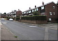
Littletown Road houses, Honiton
Houses on the south side of Littletown Road. The Co-operative Funeralcare http://www.geograph.org.uk/photo/5483632 is in the background.
Image: © Jaggery
Taken: 1 Aug 2017
0.19 miles
9
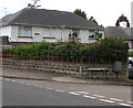
Royal Mail drop box on a Honiton corner
On the corner of Streamers Meadows and the side road to Studley House.
Image: © Jaggery
Taken: 1 Aug 2017
0.19 miles
10
South along Streamers Meadows, Honiton
Along the road named Streamers Meadows towards the Littletown Road junction.
Image: © Jaggery
Taken: 1 Aug 2017
0.20 miles