IMAGES TAKEN NEAR TO
Crosscut Way, HONITON, EX14 2DX
Introduction
This page details the photographs taken nearby to Crosscut Way, EX14 2DX by members of the Geograph project.
The Geograph project started in 2005 with the aim of publishing, organising and preserving representative images for every square kilometre of Great Britain, Ireland and the Isle of Man.

There are currently over 7.5m images from over14,400 individuals and you can help contribute to the project by visiting https://www.geograph.org.uk
Image Map
Images are licensed for reuse under creativecommons.org/licenses/by-sa/2.0
Notes
- Clicking on the map will re-center to the selected point.
- The higher the marker number, the further away the image location is from the centre of the postcode.
Image Listing (106 Images Found)
Images are licensed for reuse under creativecommons.org/licenses/by-sa/2.0
Image
Details
Distance
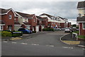
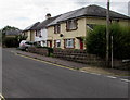
1
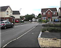
Crosscut Way, Honiton
On the west side of Marlpits Lane.
Image: © Jaggery
Taken: 1 Aug 2017
0.01 miles
2
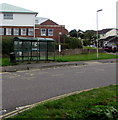
Marlpits Lane bus stop and shelter, Honiton
Between Crosscut Way and Haydons Park, near the entrance http://www.geograph.org.uk/photo/5602131 to Honiton Community Hospital.
Image: © Jaggery
Taken: 1 Aug 2017
0.04 miles
3
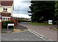
Junction of Crosscut Way and Marlpits Lane, Honiton
Crosscut Way from the left joins Marlpits Lane.
The entrance http://www.geograph.org.uk/photo/5602131 to Honiton Community Hospital is on the right.
Image: © Jaggery
Taken: 1 Aug 2017
0.04 miles
4
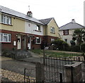
85-year-old houses, Streamers Meadows, Honiton
Viewed on August 1st 2017. A small rectangular plaque on the wall shows the year 1932.
Image: © Jaggery
Taken: 1 Aug 2017
0.05 miles
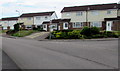
5
Woodmans Crescent, Honiton
Viewed from Crosscut Way on the west side of Marlpits Lane.
Image: © Jaggery
Taken: 1 Aug 2017
0.05 miles
6
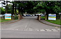
Entrance to Honiton Community Hospital, Honiton
From the east side of Marlpits Lane.
Image: © Jaggery
Taken: 1 Aug 2017
0.05 miles
7
Marlpits Lane houses, Honiton
The corner of Lower Brand Lane http://www.geograph.org.uk/photo/5483641 is on the right.
Image: © Jaggery
Taken: 1 Aug 2017
0.06 miles
8
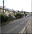
South along Streamers Meadows, Honiton
Along the road named Streamers Meadows towards the Littletown Road junction.
Image: © Jaggery
Taken: 1 Aug 2017
0.06 miles
9
West side of Streamers Meadows, Honiton
Houses on the west of the road name Streamers Meadows.
The corner of Livermore Road http://www.geograph.org.uk/photo/5483522 is on the right.
Image: © Jaggery
Taken: 1 Aug 2017
0.07 miles
10
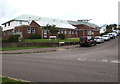
Honiton Surgery, Honiton
The Haydons Park side of the medical surgery on the corner of Marlpits Lane.
Image: © Jaggery
Taken: 1 Aug 2017
0.07 miles