IMAGES TAKEN NEAR TO
Streamers Meadows, HONITON, EX14 2DN
Introduction
This page details the photographs taken nearby to Streamers Meadows, EX14 2DN by members of the Geograph project.
The Geograph project started in 2005 with the aim of publishing, organising and preserving representative images for every square kilometre of Great Britain, Ireland and the Isle of Man.

There are currently over 7.5m images from over14,400 individuals and you can help contribute to the project by visiting https://www.geograph.org.uk
Image Map
Images are licensed for reuse under creativecommons.org/licenses/by-sa/2.0
Notes
- Clicking on the map will re-center to the selected point.
- The higher the marker number, the further away the image location is from the centre of the postcode.
Image Listing (172 Images Found)
Images are licensed for reuse under creativecommons.org/licenses/by-sa/2.0
Image
Details
Distance
1
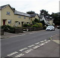
Streamers Meadows houses, Honiton
Houses on the east side of Streamers Meadows viewed from the corner of Bowling Green Lane. http://www.geograph.org.uk/photo/5483495
Image: © Jaggery
Taken: 1 Aug 2017
0.02 miles
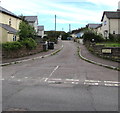
2
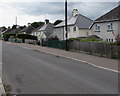
West side of Streamers Meadows, Honiton
The houses on this side of Streamers Meadows are set slightly below road level.
Image: © Jaggery
Taken: 1 Aug 2017
0.03 miles
3
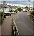
North along Streamers Meadows towards King Street, Honiton
Viewed from the elevated pavement on the right here. http://www.geograph.org.uk/photo/5483514
Image: © Jaggery
Taken: 1 Aug 2017
0.04 miles
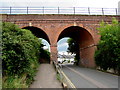
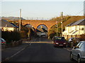
4
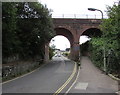
North side of the railway bridge over Streamers Meadows, Honiton
The bridge is about 250 metres west of Honiton railway station near
the point where the two tracks through the station merge into a single track.
The identifier on the side of the bridge is E4/473 BAE2 Three Meadows at Honiton.
Image: © Jaggery
Taken: 1 Aug 2017
0.04 miles
5
South side of the railway bridge over Streamers Meadows, Honiton
The bridge is about 250 metres west of Honiton railway station near
the point where the two tracks through the station merge into a single track.
The identifier on the side of the bridge is E4/473 BAE2 Three Meadows at Honiton.
Image: © Jaggery
Taken: 1 Aug 2017
0.05 miles
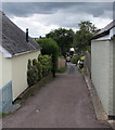
6
Mead View Road, Honiton
From the east side of the road named Streamers Meadows,
Mead View Road leads to Kendall House and Fair View Road.
Image: © Jaggery
Taken: 1 Aug 2017
0.06 miles
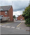
7
Bowling Green Lane, Honiton
Bowling Green Lane descends from Streamers Meadows towards Honiton Bowling Club.
Image: © Jaggery
Taken: 1 Aug 2017
0.06 miles
8
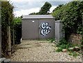
Streamers Meadows electricity substation, Honiton
Electricity substation 31/1427 is in an enclosure below the railway embankment at the edge of this http://www.geograph.org.uk/photo/5483527 bridge.
Image: © Jaggery
Taken: 1 Aug 2017
0.06 miles
9
The Age of the Railway
The main line into Exeter crosses Streamers Meadow.
Image: © Anthony Vosper
Taken: 29 Nov 2010
0.06 miles
10
Meadows Crescent, Honiton
Private road on the west side of the road named Streamers Meadows.
Image: © Jaggery
Taken: 1 Aug 2017
0.07 miles