IMAGES TAKEN NEAR TO
Argus Close, HONITON, EX14 1UT
Introduction
This page details the photographs taken nearby to Argus Close, EX14 1UT by members of the Geograph project.
The Geograph project started in 2005 with the aim of publishing, organising and preserving representative images for every square kilometre of Great Britain, Ireland and the Isle of Man.

There are currently over 7.5m images from over14,400 individuals and you can help contribute to the project by visiting https://www.geograph.org.uk
Image Map
Images are licensed for reuse under creativecommons.org/licenses/by-sa/2.0
Notes
- Clicking on the map will re-center to the selected point.
- The higher the marker number, the further away the image location is from the centre of the postcode.
Image Listing (31 Images Found)
Images are licensed for reuse under creativecommons.org/licenses/by-sa/2.0
Image
Details
Distance
1

Railway line through Honiton
This is the main Waterloo to Exeter line which has been foolishly converted to a single track line through East Devon.
Image: © Tony Atkin
Taken: 30 Aug 2005
0.01 miles
2

Orange Way in Devon and Torbay (422)
The railway line to the east of the A35 in Honiton is seen here.
Image: © Shazz
Taken: 16 Apr 2012
0.03 miles
3
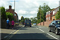
A35 Monkton Road, Honiton
The route east, but here heading west, which seems to be to do with using the A30 Honiton Bypass to take A35 traffic out of the town centre.
Image: © Robin Webster
Taken: 7 Sep 2019
0.07 miles
5
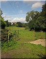
Meadow near Honiton
From Honiton Footpath 12 at the end of Hale Lane, with a meadow sandwiched between new housing on Shipley Road, and a small tributary of the Otter lined with trees.
Image: © Derek Harper
Taken: 28 Aug 2012
0.08 miles

7
Orange Way in Devon and Torbay (423)
The Orange Way turns left off the A35 along Hale Lane on the edge of Honiton.
To proceed to the next section of the Orange Way go to www.geograph.org.uk/geotrips/430.
Image: © Shazz
Taken: 16 Apr 2012
0.08 miles

9
Old Toll House by Holyshute Cross, Honiton
Toll House in the parish of Honiton (East Devon District), Holy Shute Cottage, Holyshute Cross, High Street.
Demolished in 2013
Devon & Dartmoor HER.
HER Number: MDV52300 https://www.heritagegateway.org.uk/Gateway/Results_Single.aspx?uid=MDV52300&resourceID=104
Milestone Society National ID: DV.HON04
Image: © Alan Rosevear
Taken: 10 Nov 2008
0.09 miles
10
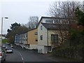
Modern apartments in Monkton Road, Honiton
Eye-catching modern architecture on the north-east of the town
Image: © David Smith
Taken: 6 Dec 2012
0.09 miles