IMAGES TAKEN NEAR TO
High Street, HONITON, EX14 1LH
Introduction
This page details the photographs taken nearby to High Street, EX14 1LH by members of the Geograph project.
The Geograph project started in 2005 with the aim of publishing, organising and preserving representative images for every square kilometre of Great Britain, Ireland and the Isle of Man.

There are currently over 7.5m images from over14,400 individuals and you can help contribute to the project by visiting https://www.geograph.org.uk
Image Map
Images are licensed for reuse under creativecommons.org/licenses/by-sa/2.0
Notes
- Clicking on the map will re-center to the selected point.
- The higher the marker number, the further away the image location is from the centre of the postcode.
Image Listing (247 Images Found)
Images are licensed for reuse under creativecommons.org/licenses/by-sa/2.0
Image
Details
Distance
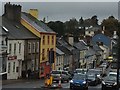
2
High Street
Buildings along the north side of Honiton High Street.
Image: © Ian Capper
Taken: 2 Feb 2019
0.01 miles

4
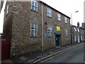
The National School, Dowell Street, Honiton
This building housed the National School from the 18th century until 1860. It was then used by Rifle Volunteers, and in WW1 housed the Honiton War Works Depot. Today it is used by the Scouts.
Image: © David Smith
Taken: 25 Oct 2013
0.01 miles
5
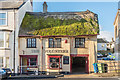
The Volunteer
17th/18th Century pub on the north side of Honiton High Street. Grade II listed - see www.historicengland.org.uk/listing/the-list/list-entry/1319801.
Image: © Ian Capper
Taken: 2 Feb 2019
0.01 miles

7
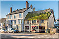
179-181 High Street and The Volunteer
Buildings on the north side of Honiton High Street. 179-181 High Street, on the left of the photo, dates from the late 18th/early 19th Century and The Volunteer dates from the 17th/18th Century. Both are grade II listed - see www.historicengland.org.uk/listing/the-list/list-entry/1116749 and www.historicengland.org.uk/listing/the-list/list-entry/1319801 respectively.
Image: © Ian Capper
Taken: 2 Feb 2019
0.02 miles
8

Dowell Street junction from A35 in Honiton
Image: © John Firth
Taken: 14 Jun 2014
0.02 miles
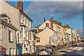
9

The way west
Honiton High Street. Once the A30 until the town was by-passed, now it's the A375.
Image: © John Lucas
Taken: 20 Feb 2024
0.02 miles
10

Honiton High Street and gutter
The gutter between the pavement and road is unusual, as it is iron, resembling large roof gutters.
Image: © David Smith
Taken: 2 Oct 2010
0.02 miles