IMAGES TAKEN NEAR TO
Millers Way, HONITON, EX14 1JB
Introduction
This page details the photographs taken nearby to Millers Way, EX14 1JB by members of the Geograph project.
The Geograph project started in 2005 with the aim of publishing, organising and preserving representative images for every square kilometre of Great Britain, Ireland and the Isle of Man.

There are currently over 7.5m images from over14,400 individuals and you can help contribute to the project by visiting https://www.geograph.org.uk
Image Map
Images are licensed for reuse under creativecommons.org/licenses/by-sa/2.0
Notes
- Clicking on the map will re-center to the selected point.
- The higher the marker number, the further away the image location is from the centre of the postcode.
Image Listing (54 Images Found)
Images are licensed for reuse under creativecommons.org/licenses/by-sa/2.0
Image
Details
Distance
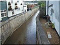
2
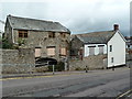
The Old Mill, Honiton
According to a Rotary Club plaque there has been a mill here since before 1792 and this mill was at work until 1968 when floods destroyed the leat supplying the overshot wheel. It was saved from demolition in 1981 and part restored. The current wheel was made in Honiton by Mickleburgh Foundry.
The mill is currently boarded up and looking worse for wear.
Image: © Chris Allen
Taken: 7 Aug 2010
0.12 miles
3
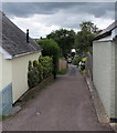
Bowling Green Lane, Honiton
Bowling Green Lane descends from Streamers Meadows towards Honiton Bowling Club.
Image: © Jaggery
Taken: 1 Aug 2017
0.13 miles
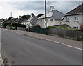
4

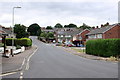
Houses in Rosemount Lane
These houses are in Rosemount lane close to the intersection with Milldale Crescent.
Image: © Nigel Mykura
Taken: 13 Jul 2019
0.15 miles
5
Littletown Rd Honiton
The photographer is in the very north east corner of the grid square and four grid squares are visible in this photo. In the left foreground is SY1699, in the right foreground is ST1600, the left background is SY1599 and the right background is ST1500.
Image: © Nigel Mykura
Taken: 13 Jul 2019
0.16 miles
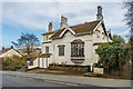
6

Ridgeway House
Early 19th Century house on Exeter Road. Grade II listed - see www.historicengland.org.uk/listing/the-list/list-entry/1097241.
Image: © Ian Capper
Taken: 8 Feb 2020
0.16 miles
8
West side of Streamers Meadows, Honiton
The houses on this side of Streamers Meadows are set slightly below road level.
Image: © Jaggery
Taken: 1 Aug 2017
0.16 miles
9
April Cottage
Early 19th Century house on Exeter Road. Grade II listed - see www.historicengland.org.uk/listing/the-list/list-entry/1170361.
Image: © Ian Capper
Taken: 8 Feb 2020
0.16 miles
10
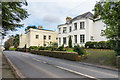
Bramble Hill House and Ernsborough Lodge
Houses on Exeter Road. Bramble Hill House, the nearer of the two, dates from the late 18th Century and is grade II listed - see www.historicengland.org.uk/listing/the-list/list-entry/1097242. Ernsborough Lodge, beyond, is now a nursing home.
Image: © Ian Capper
Taken: 8 Feb 2020
0.16 miles