IMAGES TAKEN NEAR TO
Kings Road, HONITON, EX14 1HW
Introduction
This page details the photographs taken nearby to Kings Road, EX14 1HW by members of the Geograph project.
The Geograph project started in 2005 with the aim of publishing, organising and preserving representative images for every square kilometre of Great Britain, Ireland and the Isle of Man.

There are currently over 7.5m images from over14,400 individuals and you can help contribute to the project by visiting https://www.geograph.org.uk
Image Map
Images are licensed for reuse under creativecommons.org/licenses/by-sa/2.0
Notes
- Clicking on the map will re-center to the selected point.
- The higher the marker number, the further away the image location is from the centre of the postcode.
Image Listing (35 Images Found)
Images are licensed for reuse under creativecommons.org/licenses/by-sa/2.0
Image
Details
Distance
1
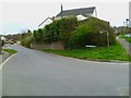
Orange Way in Devon and Torbay (423)
The Orange Way turns left off the A35 along Hale Lane on the edge of Honiton.
To proceed to the next section of the Orange Way go to www.geograph.org.uk/geotrips/430.
Image: © Shazz
Taken: 16 Apr 2012
0.06 miles
2
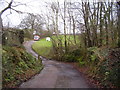
Hale Lane bridge
A small tributary of the River Otter runs under the road by the footpath sign.
Image: © Anthony Vosper
Taken: 24 Jan 2016
0.10 miles
3
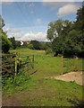
Meadow near Honiton
From Honiton Footpath 12 at the end of Hale Lane, with a meadow sandwiched between new housing on Shipley Road, and a small tributary of the Otter lined with trees.
Image: © Derek Harper
Taken: 28 Aug 2012
0.10 miles
4
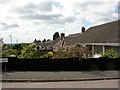
Honiton, bungalows
On Prince Park Road.
Image: © Mike Faherty
Taken: 28 Jul 2010
0.13 miles
5

Orange Way in Devon and Torbay (424)
Hale Lane arrives at a farm gate and footpath status applies from here.
Image: © Shazz
Taken: 18 Apr 2012
0.13 miles
6

Railway line through Honiton
This is the main Waterloo to Exeter line which has been foolishly converted to a single track line through East Devon.
Image: © Tony Atkin
Taken: 30 Aug 2005
0.14 miles

8

Honiton, Copper Castle
Former toll house on King's Road (A35). Early C19, with neo-Gothic door and windows, & castellation. http://www.imagesofengland.org.uk/Details/Default.aspx?id=443094&mode=adv
Image: © Mike Faherty
Taken: 28 Jul 2010
0.15 miles

