IMAGES TAKEN NEAR TO
Dairy Close, EX14 1ER
Introduction
This page details the photographs taken nearby to Dairy Close, EX14 1ER by members of the Geograph project.
The Geograph project started in 2005 with the aim of publishing, organising and preserving representative images for every square kilometre of Great Britain, Ireland and the Isle of Man.

There are currently over 7.5m images from over14,400 individuals and you can help contribute to the project by visiting https://www.geograph.org.uk
Image Map
Images are licensed for reuse under creativecommons.org/licenses/by-sa/2.0
Notes
- Clicking on the map will re-center to the selected point.
- The higher the marker number, the further away the image location is from the centre of the postcode.
Image Listing (31 Images Found)
Images are licensed for reuse under creativecommons.org/licenses/by-sa/2.0
Image
Details
Distance
1
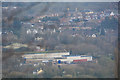
East Devon : Honiton Scenery
Looking down into Honiton with Honiton Business Park at the forefront of the picture.
Image: © Lewis Clarke
Taken: 8 Apr 2018
0.05 miles
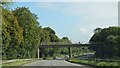
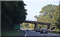
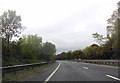
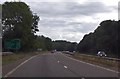
2

A30 heading west
On the Honiton Bypass.
Image: © Robin Webster
Taken: 7 Sep 2019
0.07 miles
3

Industrial Estate, Honiton
This is the smaller of two main industrial estates in the town and is typical of the modern cladded structures to be seen today. Industries include a dairy, window company and parcel courier business.
Image: © Mike Crowe
Taken: 3 Feb 2005
0.08 miles
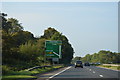

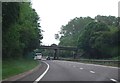
7
A30, 154 miles to London
The road curves north west of Honiton.
Image: © Julian P Guffogg
Taken: 12 Aug 2013
0.17 miles