IMAGES TAKEN NEAR TO
St. Pauls Road, HONITON, EX14 1BR
Introduction
This page details the photographs taken nearby to St. Pauls Road, EX14 1BR by members of the Geograph project.
The Geograph project started in 2005 with the aim of publishing, organising and preserving representative images for every square kilometre of Great Britain, Ireland and the Isle of Man.

There are currently over 7.5m images from over14,400 individuals and you can help contribute to the project by visiting https://www.geograph.org.uk
Image Map
Images are licensed for reuse under creativecommons.org/licenses/by-sa/2.0
Notes
- Clicking on the map will re-center to the selected point.
- The higher the marker number, the further away the image location is from the centre of the postcode.
Image Listing (44 Images Found)
Images are licensed for reuse under creativecommons.org/licenses/by-sa/2.0
Image
Details
Distance
1

Honiton : Vale Veterinary Centre
A vet on Duchy Road.
Image: © Lewis Clarke
Taken: 10 Aug 2023
0.07 miles
2

Beggars Lane, Honiton
The lane is closed at the end, so no traffic can flow from it into Exeter Road
Image: © David Smith
Taken: 3 Jun 2010
0.11 miles
3
Bridges over the South West railway line
The A375 Sidmouth Road. the green structure is a pedestrian route.
Image: © Anthony Vosper
Taken: 11 Apr 2011
0.11 miles
4
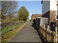
Footpath on the Heathpark Estate
To the left is the london to the south West railway line. To the right is the Heathpark estate. This was a former M.O.D site. Which was used in the 1970's to house refugees from Uganda.
Image: © Anthony Vosper
Taken: 11 Apr 2011
0.12 miles
5

St Margaret's Hospital, Honiton
This L-shaped group of three thatched cottages corresponds to Image opposite, on the other side of Icknield Street. See also Image
Image: © Derek Harper
Taken: 23 May 2006
0.12 miles
6
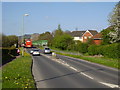
Exeter Road, Honiton
From the junction where the slip from the A35 meets Exeter Road
Image: © David Smith
Taken: 3 Jun 2010
0.12 miles
7
Beggars Lane, Honiton
Another view of the closed-off end of Image
Image: © Derek Harper
Taken: 23 May 2006
0.14 miles
8
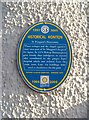
Plaque, St Margaret's Almshouses, Honiton
On the wall of Image, and placed there as part of "Historical Honiton" in 2005.
Image: © Derek Harper
Taken: 23 May 2006
0.14 miles
9

St Margaret's Hospital
Originally a leper hospital some distance from the town centre, these gothicised thatched cottages were rebuilt as almshouses in the C16 and then gothicised in the C19 http://list.english-heritage.org.uk/resultsingle.aspx?uid=1319674&searchtype=mapsearch .
Image: © Derek Harper
Taken: 23 May 2006
0.16 miles
10
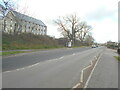
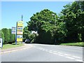
Looking West, bus stop on the Exeter Road
Image: © Anthony Vosper
Taken: 26 Feb 2022
0.16 miles