IMAGES TAKEN NEAR TO
The Orchard, HONITON, EX14 1BN
Introduction
This page details the photographs taken nearby to The Orchard, EX14 1BN by members of the Geograph project.
The Geograph project started in 2005 with the aim of publishing, organising and preserving representative images for every square kilometre of Great Britain, Ireland and the Isle of Man.

There are currently over 7.5m images from over14,400 individuals and you can help contribute to the project by visiting https://www.geograph.org.uk
Image Map
Images are licensed for reuse under creativecommons.org/licenses/by-sa/2.0
Notes
- Clicking on the map will re-center to the selected point.
- The higher the marker number, the further away the image location is from the centre of the postcode.
Image Listing (97 Images Found)
Images are licensed for reuse under creativecommons.org/licenses/by-sa/2.0
Image
Details
Distance
1
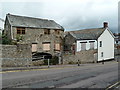
The Old Mill, Honiton
According to a Rotary Club plaque there has been a mill here since before 1792 and this mill was at work until 1968 when floods destroyed the leat supplying the overshot wheel. It was saved from demolition in 1981 and part restored. The current wheel was made in Honiton by Mickleburgh Foundry.
The mill is currently boarded up and looking worse for wear.
Image: © Chris Allen
Taken: 7 Aug 2010
0.02 miles
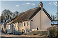
2

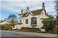
Ridgeway House
Early 19th Century house on Exeter Road. Grade II listed - see www.historicengland.org.uk/listing/the-list/list-entry/1097241.
Image: © Ian Capper
Taken: 8 Feb 2020
0.03 miles
3
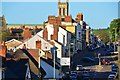
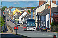
Honiton : High Street A375
Looking along Honiton High Street.
Image: © Lewis Clarke
Taken: 10 Aug 2023
0.04 miles
4
April Cottage
Early 19th Century house on Exeter Road. Grade II listed - see www.historicengland.org.uk/listing/the-list/list-entry/1170361.
Image: © Ian Capper
Taken: 8 Feb 2020
0.05 miles
5
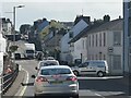
Honiton : High Street A375
Looking along the High Street of Honiton.
Image: © Lewis Clarke
Taken: 13 May 2018
0.05 miles
7
High Street
Buildings along the north side of Honiton High Street. The large thatched building is a terrace of 4 houses, nos 207-213 High Street, dating from the 17th or early 18th Century and grade II listed - see www.historicengland.org.uk/listing/the-list/list-entry/1116750. The bridge in front of it carries the road over The Gissage, a tributary of the River Otter.
Image: © Ian Capper
Taken: 2 Feb 2019
0.07 miles
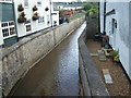
8

The Gissage in Honiton
A view of the River Gissage as viewed from the main A35 Roman Road that runs through the centre of Honiton in Devon. The Gissage runs into the River Otter to the north of Honiton.
Image: © John P Reeves
Taken: 4 Jan 2022
0.08 miles
9
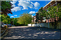
Honiton : Rockwood Close
Looking along Rockwood Close in Honiton.
Image: © Lewis Clarke
Taken: 13 May 2018
0.09 miles