IMAGES TAKEN NEAR TO
Hutchings Mead, EXETER, EX1 3XS
Introduction
This page details the photographs taken nearby to Hutchings Mead, EX1 3XS by members of the Geograph project.
The Geograph project started in 2005 with the aim of publishing, organising and preserving representative images for every square kilometre of Great Britain, Ireland and the Isle of Man.

There are currently over 7.5m images from over14,400 individuals and you can help contribute to the project by visiting https://www.geograph.org.uk
Image Map
Images are licensed for reuse under creativecommons.org/licenses/by-sa/2.0
Notes
- Clicking on the map will re-center to the selected point.
- The higher the marker number, the further away the image location is from the centre of the postcode.
Image Listing (54 Images Found)
Images are licensed for reuse under creativecommons.org/licenses/by-sa/2.0
Image
Details
Distance

2

Part of Tithebarn Copse, a section which is a foot and cycle path
Image: © David Smith
Taken: 26 May 2020
0.08 miles
4

Exeter : Pinn Lane
Pinn Lane heading through the Pinhoe area of Exeter.
Image: © Lewis Clarke
Taken: 22 Oct 2013
0.11 miles
5
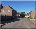
New houses, Tithebarn Lane, Monkerton
These are part of a large development
Image: © David Smith
Taken: 26 May 2020
0.11 miles
6
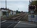
Railway line to London Waterloo
Looking east from the level crossing at Pinhoe station. The line leads to East Devon, and on to Salisbury and Waterloo
Image: © David Smith
Taken: 30 Oct 2009
0.12 miles
7

Fairview Terrace, Pinhoe
A row of houses whose view is of the fence and railway line
Image: © David Smith
Taken: 25 Jun 2020
0.12 miles
8

Tithebarn Lane, Monkerton
The start of Tithebarn Lane, an old lane which has been modified as new estates have been developed east of Pinhoe and Monkerton. This part is a cul-de-sac except for cyclists and walkers
Image: © David Smith
Taken: 26 May 2020
0.12 miles
9
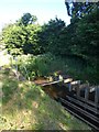
Sluice and water engineering, by Pinn Lane, Monkerton
Image: © David Smith
Taken: 26 May 2020
0.12 miles
