IMAGES TAKEN NEAR TO
Flint Field Way, EXETER, EX1 3XN
Introduction
This page details the photographs taken nearby to Flint Field Way, EX1 3XN by members of the Geograph project.
The Geograph project started in 2005 with the aim of publishing, organising and preserving representative images for every square kilometre of Great Britain, Ireland and the Isle of Man.

There are currently over 7.5m images from over14,400 individuals and you can help contribute to the project by visiting https://www.geograph.org.uk
Image Map
Images are licensed for reuse under creativecommons.org/licenses/by-sa/2.0
Notes
- Clicking on the map will re-center to the selected point.
- The higher the marker number, the further away the image location is from the centre of the postcode.
Image Listing (56 Images Found)
Images are licensed for reuse under creativecommons.org/licenses/by-sa/2.0
Image
Details
Distance
1

Flint Field Way
Flint Field Way part of new housing development
Image: © Shaun Ferguson
Taken: 27 Oct 2019
0.05 miles
2
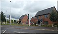
Sales office for Minerva housing estate
Image: © David Smith
Taken: 24 Jul 2020
0.08 miles
3

Sales office and show house, Minerva housing estate, West Clyst
Image: © David Smith
Taken: 22 May 2020
0.08 miles
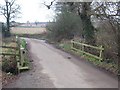
5
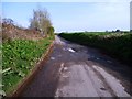
Langation Lane, near the shooting club
Small road, big potholes!
Image: © Christine Johnstone
Taken: 29 Mar 2014
0.09 miles
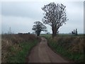
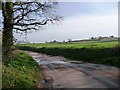
6

Trees on the bend, Langation Lane
Alongside Pin Brook.
Image: © Christine Johnstone
Taken: 29 Mar 2014
0.10 miles
7
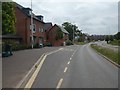
Bus stop, Minerva housing estate, West Clyst
Image: © David Smith
Taken: 22 May 2020
0.10 miles
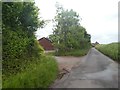
8
Farmland west of Langation Lane
Still soggy, as water has poured off into the lane.
Image: © Christine Johnstone
Taken: 29 Mar 2014
0.10 miles