
IMAGES TAKEN NEAR TO
Armlet Row, EXETER, EX1 3XJ
Introduction
This page details the photographs taken nearby to Armlet Row, EX1 3XJ by members of the Geograph project.
The Geograph project started in 2005 with the aim of publishing, organising and preserving representative images for every square kilometre of Great Britain, Ireland and the Isle of Man.

There are currently over 7.5m images from over14,400 individuals and you can help contribute to the project by visiting https://www.geograph.org.uk
Image Map
Images are licensed for reuse under creativecommons.org/licenses/by-sa/2.0
Notes
- Clicking on the map will re-center to the selected point.
- The higher the marker number, the further away the image location is from the centre of the postcode.
Image Listing (46 Images Found)
Images are licensed for reuse under creativecommons.org/licenses/by-sa/2.0
Image
Details
Distance

2

Covid-19 warnings on construction site, Minerva housing estate
Image: © David Smith
Taken: 4 Jul 2020
0.05 miles
3
Three seats by Tithebarn Lane
The nearer two have a view of the hedge, the third looks towards the housing estate
Image: © David Smith
Taken: 22 May 2020
0.05 miles
6

Construction work by Stone Barton Road, on Minerva housing estate
Image: © David Smith
Taken: 4 Jul 2020
0.06 miles
7

Flint Field Way
Flint Field Way part of new housing development
Image: © Shaun Ferguson
Taken: 27 Oct 2019
0.07 miles
8
Bus stop, Minerva housing estate, West Clyst
Image: © David Smith
Taken: 22 May 2020
0.07 miles
9
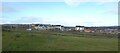
View to Minerva housing development (2)
Taken from the same position as Image but six months later.
Image: © David Smith
Taken: 12 Dec 2020
0.08 miles
10
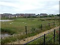
Redhayes Green Corridor, Minerva housing estate
An area between Stone Barton Road and Tithebarn Lane has been designated as a "Green Corridor" of open space with paths and pools, with the potential for flood prevention
Image: © David Smith
Taken: 4 Jul 2020
0.08 miles