IMAGES TAKEN NEAR TO
West Clyst, EXETER, EX1 3TJ
Introduction
This page details the photographs taken nearby to EX1 3TJ by members of the Geograph project.
The Geograph project started in 2005 with the aim of publishing, organising and preserving representative images for every square kilometre of Great Britain, Ireland and the Isle of Man.

There are currently over 7.5m images from over14,400 individuals and you can help contribute to the project by visiting https://www.geograph.org.uk
Image Map
Images are licensed for reuse under creativecommons.org/licenses/by-sa/2.0
Notes
- Clicking on the map will re-center to the selected point.
- The higher the marker number, the further away the image location is from the centre of the postcode.
Image Listing (79 Images Found)
Images are licensed for reuse under creativecommons.org/licenses/by-sa/2.0
Image
Details
Distance
1

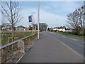
Wiggly path by Pinn Hill
Leading from the B3181 to houses on Hay Webb Close.
Image: © Derek Harper
Taken: 15 May 2015
0.02 miles
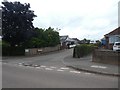
3
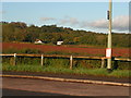
Westclyst
These houses are separated from Pinhoe by fields, creating a separate community.
Image: © David Smith
Taken: 20 Jan 2011
0.02 miles
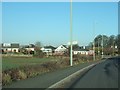
4

Westclyst and the B3181
The road was the A38 until its role was taken by the M5.
Image: © David Smith
Taken: 20 Jan 2011
0.02 miles
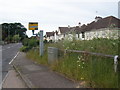
8
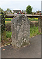
Old Milestone by the B3181, West Clyst, East Devon
Carved stone post by the B3181 (was A38), in parish of BROAD CLYST (EAST DEVON District), West Clyst, just West of the bus stop, in pavement, beside wooden fence, on North side of road. Exeter tombstone, erected by the Exeter turnpike trust in the 19th century.
Inscription reads:- : 3 / MILES / FROM / EXETER :
on rear https://www.flickr.com/photos/tollhouses/5625063173 is carved (2?) / Miles / From / Exon / :
Carved benchmark and rivet on top.
Milestone Society National ID: DV_EXCM03.
Image: © Alan Rosevear
Taken: 16 Apr 2011
0.05 miles
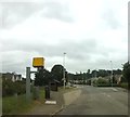
9
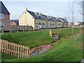
Houses by the main road, Hillside Gardens
On the west side of the former A38. This new housing development is mapped on the Exeter street plan, but not yet on the OS.
Image: © Christine Johnstone
Taken: 29 Mar 2014
0.05 miles
10
Milestone from the south-west, West Clyst
On the north side of the B3181, the Exeter - Taunton Road. This side says '.. miles from Exon'. The number is illegible, but it's just over 3 miles to the Cathedral. The other side gives the distance from Exeter.
Image: © Christine Johnstone
Taken: 29 Mar 2014
0.05 miles