IMAGES TAKEN NEAR TO
Fitzroy Road, EXETER, EX1 3PB
Introduction
This page details the photographs taken nearby to Fitzroy Road, EX1 3PB by members of the Geograph project.
The Geograph project started in 2005 with the aim of publishing, organising and preserving representative images for every square kilometre of Great Britain, Ireland and the Isle of Man.

There are currently over 7.5m images from over14,400 individuals and you can help contribute to the project by visiting https://www.geograph.org.uk
Image Map
Images are licensed for reuse under creativecommons.org/licenses/by-sa/2.0
Notes
- Clicking on the map will re-center to the selected point.
- The higher the marker number, the further away the image location is from the centre of the postcode.
Image Listing (29 Images Found)
Images are licensed for reuse under creativecommons.org/licenses/by-sa/2.0
Image
Details
Distance
1
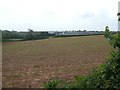
View towards the Met Office from Hollow Lane, Exeter
Looking across open fields, which are - so far - undeveloped
Image: © David Smith
Taken: 22 May 2020
0.01 miles
2

Met Office by night
After dark, anyway, and seen from the path shown in Image
Image: © Derek Harper
Taken: 20 Feb 2017
0.06 miles
3
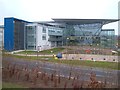
Met Office, Exeter
Built in 2003. The architect was Broadway Malyan, and it won them the Royal Town Planning Institute's Planning Process Award and Contract Journal's Public Private Partnership of the Year, as well as IAS/OAS Property Week's Best Office Development and numerous shortlistings; steel construction was by Bourne Western http://www.bournegroup.eu/western/projects-western/met-office-hq.html . See also http://www.coltgroup.com/projects/offices/met-office/ .
Image: © Derek Harper
Taken: 20 Mar 2006
0.09 miles
4
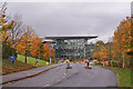
Entrance to the Met Office
Trees in their autumn colour line the Fitzroy Road approach to the Met Office. 'Met' is an abbreviation of meteorological. The Met Office is the UK's National Weather Service.
Image: © Richard Dorrell
Taken: 8 Nov 2013
0.11 miles
5
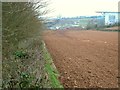
Ploughed field beside Exeter Business Park
A long narrow arable field surviving at the western edge of Exeter Business Park. On the right is the Met Office.
Image: © Derek Harper
Taken: 20 Mar 2006
0.13 miles
6

Path near the Met Office
Image: © Derek Harper
Taken: 8 Jun 2016
0.14 miles
7

Florence Way, Exeter
Part of a 21st century housing estate
Image: © David Smith
Taken: 21 Nov 2020
0.14 miles
8

Cycle path on edge of Exeter
This runs between a housing estate on the left and the Met Office
Image: © David Smith
Taken: 21 Nov 2020
0.14 miles
9

Eastern edge of a housing estate, Whipton in Exeter
The dome just left of centre is a weather radar system for the Met Office
Image: © David Smith
Taken: 21 Nov 2020
0.15 miles
10

Path near the Met Office
A cycle and footpath from Fitzroy Road to Hill Barton Road. I've a hunch that the barriers mean that the adjacent field won't remain a field for long, and a little research suggests that this could be the site for 750 new homes.
Image: © Derek Harper
Taken: 21 Feb 2016
0.16 miles