IMAGES TAKEN NEAR TO
Grambrel Rise, EX1 3FR
Introduction
This page details the photographs taken nearby to Grambrel Rise, EX1 3FR by members of the Geograph project.
The Geograph project started in 2005 with the aim of publishing, organising and preserving representative images for every square kilometre of Great Britain, Ireland and the Isle of Man.

There are currently over 7.5m images from over14,400 individuals and you can help contribute to the project by visiting https://www.geograph.org.uk
Image Map
Images are licensed for reuse under creativecommons.org/licenses/by-sa/2.0
Notes
- Clicking on the map will re-center to the selected point.
- The higher the marker number, the further away the image location is from the centre of the postcode.
Image Listing (47 Images Found)
Images are licensed for reuse under creativecommons.org/licenses/by-sa/2.0
Image
Details
Distance
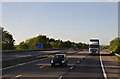
2
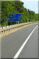
M5 Sign and Hard Shoulder near Monkerton
Image: © David Dixon
Taken: 25 Jul 2018
0.09 miles
3

M5 north near Pinhoe
The M5 is tight in this square but the sign is in SX9694 from Where's The Path
Image: © John Firth
Taken: 28 Oct 2015
0.09 miles
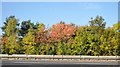
5
Exeter District : The M5 Motorway
Heading north through Devon and beyond Exeter.
Image: © Lewis Clarke
Taken: 5 Nov 2013
0.09 miles
6
Exeter District : The M5 Motorway
The M5 Motorway heading beside Pinhoe near Exeter.
Image: © Lewis Clarke
Taken: 22 May 2013
0.10 miles
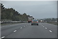
7

East Devon : The M5 Motorway
Traffic on the M5 Motorway near Exeter.
Image: © Lewis Clarke
Taken: 20 Oct 2016
0.11 miles
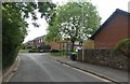
8
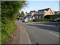
Houses, south side, Langation Lane, Pinhoe, Exeter
The M5 is out of sight, but not out of earshot.
Image: © Christine Johnstone
Taken: 29 Mar 2014
0.11 miles
9
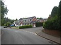
Dormer bungalows, Langaton Lane, Pinhoe
Image: © David Smith
Taken: 22 May 2020
0.12 miles
10

Fairview Terrace, Pinhoe
A row of houses whose view is of the fence and railway line
Image: © David Smith
Taken: 25 Jun 2020
0.13 miles