IMAGES TAKEN NEAR TO
Sybil Mead, EXETER, EX1 3FA
Introduction
This page details the photographs taken nearby to Sybil Mead, EX1 3FA by members of the Geograph project.
The Geograph project started in 2005 with the aim of publishing, organising and preserving representative images for every square kilometre of Great Britain, Ireland and the Isle of Man.

There are currently over 7.5m images from over14,400 individuals and you can help contribute to the project by visiting https://www.geograph.org.uk
Image Map
Images are licensed for reuse under creativecommons.org/licenses/by-sa/2.0
Notes
- Clicking on the map will re-center to the selected point.
- The higher the marker number, the further away the image location is from the centre of the postcode.
Image Listing (80 Images Found)
Images are licensed for reuse under creativecommons.org/licenses/by-sa/2.0
Image
Details
Distance
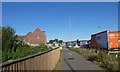
1
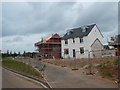
Housing development, Gipsy Hill, Exeter
Image: © David Smith
Taken: 22 May 2020
0.05 miles
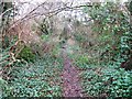
4

Exeter : Pinn Lane
Pinn Lane heading under the canopy of trees.
Image: © Lewis Clarke
Taken: 22 Oct 2013
0.07 miles
5
Sales office for new houses, Gipsy Hill, Exeter
Image: © David Smith
Taken: 22 May 2020
0.07 miles
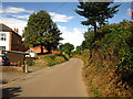
6

Exeter : City Scenery
Looking across the outskirts of Exeter from Gipsy Hill Lane.
Image: © Lewis Clarke
Taken: 30 May 2013
0.07 miles
7

Exeter : City Outskirts
Looking across the outskirts of Exeter from Gipsy Hill Lane.
Image: © Lewis Clarke
Taken: 30 May 2013
0.08 miles
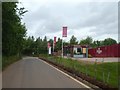
8

Gipsy Hill Hotel
Just off Junction 29 of the M5. http://www.gipsyhillhotel.co.uk/
Image: © Chris Holifield
Taken: 25 Jul 2011
0.10 miles

10
Tithebarn Way from the cycle bridge over M5
Tithebarn Way leads to a new housing estate
Image: © David Smith
Taken: 26 May 2020
0.11 miles