IMAGES TAKEN NEAR TO
Musbury, AXMINSTER, EX13 8SU
Introduction
This page details the photographs taken nearby to EX13 8SU by members of the Geograph project.
The Geograph project started in 2005 with the aim of publishing, organising and preserving representative images for every square kilometre of Great Britain, Ireland and the Isle of Man.

There are currently over 7.5m images from over14,400 individuals and you can help contribute to the project by visiting https://www.geograph.org.uk
Image Map
Images are licensed for reuse under creativecommons.org/licenses/by-sa/2.0
Notes
- Clicking on the map will re-center to the selected point.
- The higher the marker number, the further away the image location is from the centre of the postcode.
Image Listing (15 Images Found)
Images are licensed for reuse under creativecommons.org/licenses/by-sa/2.0
Image
Details
Distance
1
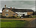
Axmouth: Higher Bruckland Farm
In Bruckland Lane. Looking east
Image: © Martin Bodman
Taken: 16 Dec 2006
0.01 miles
3
Higher Bruckland Farm
Seen from the edge of the square on Bruckland Lane. The farm is described at http://list.english-heritage.org.uk/resultsingle.aspx?uid=1098629&searchtype=mapsearch . Behind rises Edge Hill.
Image: © Derek Harper
Taken: 15 Sep 2012
0.02 miles
4
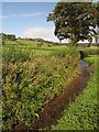
Stream, Higher Bruckland Farm
Running towards the camera beside Axmouth Footpath 11. Hemp agrimony grows on the bank.
Image: © Derek Harper
Taken: 15 Sep 2012
0.03 miles
5
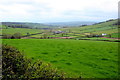
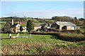
Higher Bruckland
Higher Bruckland Farm is the larger group of buildings in the centre of the image viewed from the farmers track that runs round the north side of Edge Hill near Combpyne.
Image: © Nigel Mykura
Taken: 14 Apr 2019
0.03 miles
6
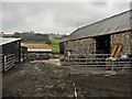
Yard at Higher Bruckland Farm
During a spell of heavy rain!
Image: © Roger Cornfoot
Taken: 29 Aug 2018
0.04 miles
7
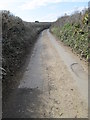
Bruckland Lane
Looking west down Bruckland Lane.
Image: © T Eyre
Taken: 5 Apr 2013
0.10 miles
8
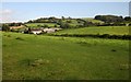
Bruckland valley
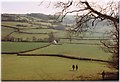
From the East Devon Way following Axmouth Footpath 12 down to the valley floor, which it reaches on the right near Higher Bruckland Farm and then turns left, past Higher Bruckland Cottage. An event is taking place below. In the background is the Combpune valley.
Image: © Derek Harper
Taken: 15 Sep 2012
0.11 miles
9
East Devon Way approaching Higher Bruckland, 1996
Compare with Image, taken over 16 years later. Higher Bruckland Cottage is the house common to both.
Image: © Derek Harper
Taken: Unknown
0.11 miles
10
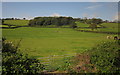
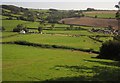
Pasture, Higher Bruckland Farm
From Axmouth Footpath 11, looking towards Crocker's Pit Coppice on the hillside below Musbury Castle.
Image: © Derek Harper
Taken: 15 Sep 2012
0.12 miles