IMAGES TAKEN NEAR TO
Membury, AXMINSTER, EX13 7TP
Introduction
This page details the photographs taken nearby to EX13 7TP by members of the Geograph project.
The Geograph project started in 2005 with the aim of publishing, organising and preserving representative images for every square kilometre of Great Britain, Ireland and the Isle of Man.

There are currently over 7.5m images from over14,400 individuals and you can help contribute to the project by visiting https://www.geograph.org.uk
Image Map
Images are licensed for reuse under creativecommons.org/licenses/by-sa/2.0
Notes
- Clicking on the map will re-center to the selected point.
- The higher the marker number, the further away the image location is from the centre of the postcode.
Image Listing (5 Images Found)
Images are licensed for reuse under creativecommons.org/licenses/by-sa/2.0
Image
Details
Distance
1
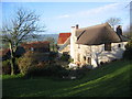
Osmore Farm
Photograph taken from the walled garden just above the farmhouse. The building is Grade II listed and originally dates back to the 14th century
Image: © Sandy Winskill
Taken: 2 Feb 2007
0.05 miles
2
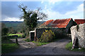
Membury: Osmore Farm
Looking west to the Yarty valley by the farm entrance
Image: © Martin Bodman
Taken: 2 Dec 2006
0.05 miles
3
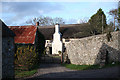
Membury: Osmore Farm
Looking north west
Image: © Martin Bodman
Taken: 2 Dec 2006
0.05 miles
4
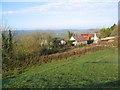
Osmore Farm
Photograph taken from field above the farm buildings, looking North West across the Yarty valley.
Image: © Sandy Winskill
Taken: 2 Feb 2007
0.07 miles
5
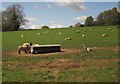
Sheep near Furley
With Moor Copse on the left. The field is crossed by Membury Footpath 25.
Image: © Derek Harper
Taken: 16 May 2013
0.20 miles