IMAGES TAKEN NEAR TO
Membury, AXMINSTER, EX13 7TF
Introduction
This page details the photographs taken nearby to EX13 7TF by members of the Geograph project.
The Geograph project started in 2005 with the aim of publishing, organising and preserving representative images for every square kilometre of Great Britain, Ireland and the Isle of Man.

There are currently over 7.5m images from over14,400 individuals and you can help contribute to the project by visiting https://www.geograph.org.uk
Image Map
Images are licensed for reuse under creativecommons.org/licenses/by-sa/2.0
Notes
- Clicking on the map will re-center to the selected point.
- The higher the marker number, the further away the image location is from the centre of the postcode.
Image Listing (25 Images Found)
Images are licensed for reuse under creativecommons.org/licenses/by-sa/2.0
Image
Details
Distance


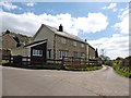
3

Clarence Farm
This pair of semi-detached houses sits at Clarence Cross. The houses have been built since December 2011 when planning permission was given.
Image: © Nigel Mykura
Taken: 7 Aug 2015
0.08 miles
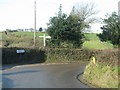
5

Field near Star Cross
This pasture field north west of the cross had only a few sheep in it , put there quite recently after a cut of hay or silage had been taken from the field. In the middle distance can be seen new House Farm.
Image: © Nigel Mykura
Taken: 7 Aug 2015
0.10 miles
6
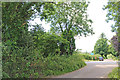
Star Cross
Site of old cottage in trees on the left.
Image: © Nick Chipchase
Taken: 8 Jul 2016
0.10 miles


10
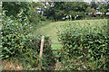
Membury: footpath to Membury Castle
Membury Castle is a late iron age fort which was defended by a single rampart and steep slopes on its western side. It stands above and to the east of the Yarty valley and W G Hoskins attributes it to the Dumnonii tribe as part of a system of defences against the Dorset-based Durotriges. The village is named after the fort: Membury = ‘stone fort’
Image: © Martin Bodman
Taken: 1 Sep 2006
0.13 miles