IMAGES TAKEN NEAR TO
The Street, AXMINSTER, EX13 7SH
Introduction
This page details the photographs taken nearby to The Street, EX13 7SH by members of the Geograph project.
The Geograph project started in 2005 with the aim of publishing, organising and preserving representative images for every square kilometre of Great Britain, Ireland and the Isle of Man.

There are currently over 7.5m images from over14,400 individuals and you can help contribute to the project by visiting https://www.geograph.org.uk
Image Map
Images are licensed for reuse under creativecommons.org/licenses/by-sa/2.0
Notes
- Clicking on the map will re-center to the selected point.
- The higher the marker number, the further away the image location is from the centre of the postcode.
Image Listing (26 Images Found)
Images are licensed for reuse under creativecommons.org/licenses/by-sa/2.0
Image
Details
Distance

3
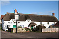
Kilmington: New Inn
This was one of the few pubs in the entire country to feature throughout the first sixteen editions of CAMRA’s Good Beer Guide. In 1989 it was noted as having a typical village public bar with table skittles and a darts board. There was also a tiny lounge. [Source: Tim Webb, The Best Pubs in Devon & Cornwall, Alma Books, 1989]. Looking north
Image: © Martin Bodman
Taken: 16 Dec 2006
0.10 miles
4
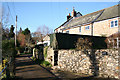
Kilmington: Silver Street
A just drivable narrow village lane. Looking west-north-west.
Image: © Martin Bodman
Taken: 16 Dec 2006
0.10 miles
5
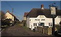
New Inn, Kilmington
Another view of Image, on The Hill, which takes a double bend past the 8-long row Balfour Terrace.
Image: © Derek Harper
Taken: 5 Dec 2012
0.11 miles
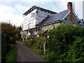
6

Cottages on The Hill, Kilmington
Just north of Image], this row of three C18 cottages is listed http://list.english-heritage.org.uk/resultsingle.aspx?uid=1098464&searchtype=mapsearch
Image: © Derek Harper
Taken: 5 Dec 2012
0.13 miles
7
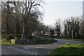
War memorial, Kilmington
Between the A35 and Roman Road.
Image: © Richard Webb
Taken: 8 Apr 2015
0.15 miles

9

Field on The Hill
Kilmington is built on a long east-facing slope, and this part of the hill is mapped as: "The Hill". This field is adjacent to Image], and is also seen from Springhead Lane.
Image: © Derek Harper
Taken: 5 Dec 2012
0.15 miles
10
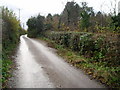
Passing place in Bim Bom Lane
An interesting name for a country lane.
Image: © Peter Holmes
Taken: 16 Nov 2008
0.15 miles