IMAGES TAKEN NEAR TO
Old Taunton Road, AXMINSTER, EX13 7QD
Introduction
This page details the photographs taken nearby to Old Taunton Road, EX13 7QD by members of the Geograph project.
The Geograph project started in 2005 with the aim of publishing, organising and preserving representative images for every square kilometre of Great Britain, Ireland and the Isle of Man.

There are currently over 7.5m images from over14,400 individuals and you can help contribute to the project by visiting https://www.geograph.org.uk
Image Map
Images are licensed for reuse under creativecommons.org/licenses/by-sa/2.0
Notes
- Clicking on the map will re-center to the selected point.
- The higher the marker number, the further away the image location is from the centre of the postcode.
Image Listing (15 Images Found)
Images are licensed for reuse under creativecommons.org/licenses/by-sa/2.0
Image
Details
Distance
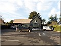
1

Merrydown Camping, Old Taunton Road, Dalwood
Image: © Jo and Steve Turner
Taken: 21 Aug 2021
0.04 miles
2
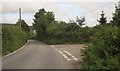
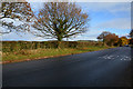
Road junction, Smiter's Pit
Smiter's Pit Lane is the turning to the right off the road to Taunton Cross.
Image: © Derek Harper
Taken: 28 Aug 2012
0.06 miles
3
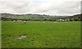
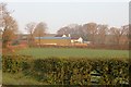
Sheep near Andrewshayes Farm
That's Andrewshayes Farm on the right.
Image: © Derek Harper
Taken: 28 Aug 2012
0.08 miles

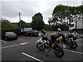


9
East Devon : Road
A road heading off from the A35.
Image: © Lewis Clarke
Taken: 19 Nov 2016
0.15 miles
10
Taunton Cross
View across fields to a garage on the A35.
Image: © Richard Webb
Taken: 9 Apr 2015
0.17 miles