IMAGES TAKEN NEAR TO
Shute, AXMINSTER, EX13 7PY
Introduction
This page details the photographs taken nearby to EX13 7PY by members of the Geograph project.
The Geograph project started in 2005 with the aim of publishing, organising and preserving representative images for every square kilometre of Great Britain, Ireland and the Isle of Man.

There are currently over 7.5m images from over14,400 individuals and you can help contribute to the project by visiting https://www.geograph.org.uk
Image Map
Images are licensed for reuse under creativecommons.org/licenses/by-sa/2.0
Notes
- Clicking on the map will re-center to the selected point.
- The higher the marker number, the further away the image location is from the centre of the postcode.
Image Listing (17 Images Found)
Images are licensed for reuse under creativecommons.org/licenses/by-sa/2.0
Image
Details
Distance
1

East Devon : The A35
On the road between Honiton and Dorchester.
Image: © Lewis Clarke
Taken: 12 Oct 2009
0.13 miles
2

East Devon : The A35
Thirty miles from Dorchester, and 34 from Weymouth.
Image: © Lewis Clarke
Taken: 12 Oct 2009
0.15 miles
3

Shute: stone gateposts
Looking north-north-west on the road from Seaton and Colyton. A public footpath runs on ahead. The main road rounds the corner to join the A35 at Taunton Cross. On the right a lane leads to Shute Hill Farm; this was once a Roman road linking the Fosse Way with Exeter. The gateposts probably relate to Shute House, a property once belonging to the Pole family, and they – together with the Roman road – mark the parish boundary
Image: © Martin Bodman
Taken: 6 Dec 2006
0.16 miles
4

Shute: Roman road
This highway once linked the Fosse Way in the Axe valley with Exeter. The Fosse Way terminated with a harbour at Axmouth. The route now merely provides access to Shute Hill Farm and has been supplanted by the A35 Trunk Road, which runs to the north of Kilmington Hill. Looking east-north-east
Image: © Martin Bodman
Taken: 6 Dec 2006
0.16 miles
5
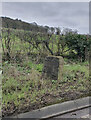
Old Milestone by the A35, north of Shute
Metal plate attached to stone post by the A35, in parish of SHUTE (EAST DEVON District), 200m South of Lobelia House, on grass verge, very close to road edge, on South side of road. Axminster T-iron plate, erected by the Axminster (Devon & Dorset) turnpike trust in the 19th century.
Inscription reads:- : HONITON / 6 : : AXMINSTER / 3 :
Milestone Society National ID: DV_AXHN03.
Image: © Colin Payne
Taken: 16 Feb 2024
0.17 miles
6
Old Milestone by the A35, north of Shute
Metal plate attached to stone post by the A35, in parish of SHUTE (EAST DEVON District), 200m South of Lobelia House, on grass verge, very close to road edge, on South side of road. Axminster T-iron plate, erected by the Axminster (Devon & Dorset) turnpike trust in the 19th century.
Inscription reads:- : HONITON / 6 : : AXMINSTER / 3 :
Milestone Society National ID: DV_AXHN03.
Image: © Alan Rosevear
Taken: 27 Apr 2011
0.17 miles
7

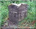
Shute Piers, Shute Road, Bakers Mead, Shute
Positioned alongside an old Roman and turnpike road the piers were presumably the gateway to the Shute Estate. Graffiti on the piers indicate a date of 1763. Sir John William de la Pole, 6th Baronet (1757 to 1799) (MP for the rotten borough of West Looe) in 1787 built the 'New Shute House'. The 5th Baronet died in 1760 so it is possible the piers are later than 1763. The east pier was damaged by a car in 2008 and repaired at a cost of about £34,000, the cost met by the insurance company. In March 2011 however another car crashed into it completely demolishing it. The pier was re-built around the end of the same year.
Image: © Jo and Steve Turner
Taken: 22 Aug 2021
0.18 miles
8

One of the Shute Piers
One of the gateposts marking the entrance to the Shute estate
Image: © David Smith
Taken: 25 Jun 2016
0.18 miles
9
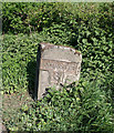
Old stone milepost on the A35
A well-worn milepost 6 miles from Honiton and 3 miles from Axminster.
To see some 360°Panoramas of Devon please visit this http://www.360panoramas.co.uk
Image: © M Etherington
Taken: 9 May 2007
0.19 miles