IMAGES TAKEN NEAR TO
Shute, AXMINSTER, EX13 7PA
Introduction
This page details the photographs taken nearby to EX13 7PA by members of the Geograph project.
The Geograph project started in 2005 with the aim of publishing, organising and preserving representative images for every square kilometre of Great Britain, Ireland and the Isle of Man.

There are currently over 7.5m images from over14,400 individuals and you can help contribute to the project by visiting https://www.geograph.org.uk
Image Map
Images are licensed for reuse under creativecommons.org/licenses/by-sa/2.0
Notes
- Clicking on the map will re-center to the selected point.
- The higher the marker number, the further away the image location is from the centre of the postcode.
Image Listing (7 Images Found)
Images are licensed for reuse under creativecommons.org/licenses/by-sa/2.0
Image
Details
Distance
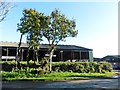
3
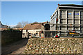
Shute: farm at Hampton
Looking west-north-west towards a barn, with a sheep truck on the right
Image: © Martin Bodman
Taken: 16 Dec 2006
0.01 miles
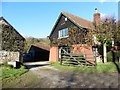
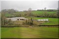
5
Shute: buildings at Hampton
These barns belong to Hampton and Lower Hampton Farms. Looking north-north-east
Image: © Martin Bodman
Taken: 16 Dec 2006
0.07 miles