IMAGES TAKEN NEAR TO
Churchill, AXMINSTER, EX13 7LZ
Introduction
This page details the photographs taken nearby to EX13 7LZ by members of the Geograph project.
The Geograph project started in 2005 with the aim of publishing, organising and preserving representative images for every square kilometre of Great Britain, Ireland and the Isle of Man.

There are currently over 7.5m images from over14,400 individuals and you can help contribute to the project by visiting https://www.geograph.org.uk
Image Map
Images are licensed for reuse under creativecommons.org/licenses/by-sa/2.0
Notes
- Clicking on the map will re-center to the selected point.
- The higher the marker number, the further away the image location is from the centre of the postcode.
Image Listing (12 Images Found)
Images are licensed for reuse under creativecommons.org/licenses/by-sa/2.0
Image
Details
Distance
3

Chardstock: Churchill Farm
Seen from the public footpath at Churchill Lane; the field is accessed up a steep flight of steps from the lane
Image: © Martin Bodman
Taken: 1 Sep 2006
0.13 miles

5
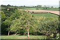
Chardstock: orchard above Churchill
Looking east-north-east above a valley to the south west of Chardstock village
Image: © Martin Bodman
Taken: 1 Sep 2006
0.19 miles
6
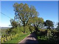
Smallridge Road
Running down a ridge towards the village of Smallridge, and seen here at Cranborne Farm.
Image: © Derek Harper
Taken: 16 May 2013
0.19 miles
7
Membury: by Dennings Down
Looking west-south-west on a footpath from Smallridge Road: it runs to Membury Road, near Lewsley Cross. On the Membury-Axminster parish border
Image: © Martin Bodman
Taken: 1 Sep 2006
0.21 miles
8
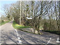
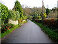
Fork in the road near Churchill, Devon
Smallridge Road heads left, down hill right to Churchill village.
Image: © Jonathan Billinger
Taken: 15 Mar 2007
0.22 miles
9

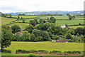
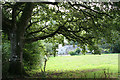
Valley at Churchill
The valley of a tributary of the Axe, seen from the stretch of lane shown in Image To the left behind the trees at the foot of the field is Undercleave Farm; to the right, part of Dennings Down Farm. On the far side, a belt of woodland (Lower Rag Copse) on the right follows a side stream; the parallel field boundary just to its left, climbing away from the camera, is followed by Membury Footpath 6, which leaves Smallridge Road a few metres to the right of the camera.
Image: © Derek Harper
Taken: 16 May 2013
0.23 miles
