IMAGES TAKEN NEAR TO
Knights Lane, AXMINSTER, EX13 7LS
Introduction
This page details the photographs taken nearby to Knights Lane, EX13 7LS by members of the Geograph project.
The Geograph project started in 2005 with the aim of publishing, organising and preserving representative images for every square kilometre of Great Britain, Ireland and the Isle of Man.

There are currently over 7.5m images from over14,400 individuals and you can help contribute to the project by visiting https://www.geograph.org.uk
Image Map
Images are licensed for reuse under creativecommons.org/licenses/by-sa/2.0
Notes
- Clicking on the map will re-center to the selected point.
- The higher the marker number, the further away the image location is from the centre of the postcode.
Image Listing (13 Images Found)
Images are licensed for reuse under creativecommons.org/licenses/by-sa/2.0
Image
Details
Distance
1

Goldsmiths Lane
A straight road from All Saints Cross, with occasional houses on either side.
Image: © Derek Harper
Taken: 16 May 2013
0.15 miles
2
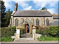
Cottage at All Saints
All Saints gets its name from the old rectory of the church in Smallridge, the village just to the west of here. The rectory for All Saints is the large house now called All Saints House which stands close by here a few hundred metres south of here. This actual location was formerly known as Higher Coaxdon.
All Saints cross can be seen in the distance where this lane meets Goldsmiths Lane
Image: © Nigel Mykura
Taken: 12 Mar 2017
0.17 miles
3
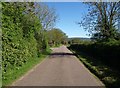
Goldsmiths Lane
Another (but not the same) straight stretch of the road shown in Image A few metres away on the left is a crescent on the left with 8 properties.
Image: © Derek Harper
Taken: 16 May 2013
0.18 miles
4
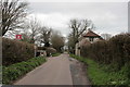
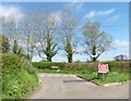
All Saints Cross road junction
Here the road from the church joins Goldsmith's Lane (why that name?)
Image: © David Smith
Taken: 28 Dec 2013
0.20 miles
6
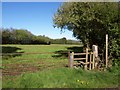
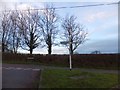
Stile, Goldsmiths Lane
The stile, leading onto All Saints Footpath 57, is also visible in Image
Image: © Derek Harper
Taken: 16 May 2013
0.21 miles
7
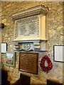
War memorials, All Saints
Two war memorials; the upper one is for WW1 and the deaths are listed by rank. The lower one orders the honoured dead of WW2 in an egalitarian way, alphabetically by surname.
Image: © David Smith
Taken: 28 Dec 2013
0.21 miles
8
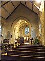
The nave and chancel of All Saints church, All Saints
Image: © David Smith
Taken: 28 Dec 2013
0.21 miles
9
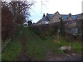
Footpath from church and school to All Saints village
This path forks behind the school (on the right) and the two paths link with the main village street of All Saints
Image: © David Smith
Taken: 28 Dec 2013
0.21 miles