IMAGES TAKEN NEAR TO
All Saints, AXMINSTER, EX13 7LR
Introduction
This page details the photographs taken nearby to EX13 7LR by members of the Geograph project.
The Geograph project started in 2005 with the aim of publishing, organising and preserving representative images for every square kilometre of Great Britain, Ireland and the Isle of Man.

There are currently over 7.5m images from over14,400 individuals and you can help contribute to the project by visiting https://www.geograph.org.uk
Image Map
Images are licensed for reuse under creativecommons.org/licenses/by-sa/2.0
Notes
- Clicking on the map will re-center to the selected point.
- The higher the marker number, the further away the image location is from the centre of the postcode.
Image Listing (17 Images Found)
Images are licensed for reuse under creativecommons.org/licenses/by-sa/2.0
Image
Details
Distance

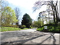
5
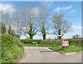
All Saints Cross road junction
Here the road from the church joins Goldsmith's Lane (why that name?)
Image: © David Smith
Taken: 28 Dec 2013
0.10 miles
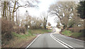
7

Bus stop on A358
This serves the village of All Saints, but there is no provision of shelter for travellers
Image: © David Smith
Taken: 30 Dec 2019
0.10 miles
8
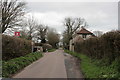
Cottage at All Saints
All Saints gets its name from the old rectory of the church in Smallridge, the village just to the west of here. The rectory for All Saints is the large house now called All Saints House which stands close by here a few hundred metres south of here. This actual location was formerly known as Higher Coaxdon.
All Saints cross can be seen in the distance where this lane meets Goldsmiths Lane
Image: © Nigel Mykura
Taken: 12 Mar 2017
0.12 miles
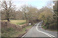
9

Valley and lay-by on A358 east of All Saints
There is a stream marked in this valley, running east to the Axe
Image: © David Smith
Taken: 30 Dec 2019
0.12 miles
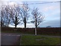
10
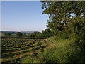
Field near Waggs Plot
The A358 is behind the trees on the right, and the freshly-cut field is seen from a gateway close to where the lane called Waggs Plot joins the main road.
Image: © Derek Harper
Taken: 5 Jun 2007
0.14 miles