IMAGES TAKEN NEAR TO
Birchill, AXMINSTER, EX13 7LB
Introduction
This page details the photographs taken nearby to EX13 7LB by members of the Geograph project.
The Geograph project started in 2005 with the aim of publishing, organising and preserving representative images for every square kilometre of Great Britain, Ireland and the Isle of Man.

There are currently over 7.5m images from over14,400 individuals and you can help contribute to the project by visiting https://www.geograph.org.uk
Image Map
Images are licensed for reuse under creativecommons.org/licenses/by-sa/2.0
Notes
- Clicking on the map will re-center to the selected point.
- The higher the marker number, the further away the image location is from the centre of the postcode.
Image Listing (10 Images Found)
Images are licensed for reuse under creativecommons.org/licenses/by-sa/2.0
Image
Details
Distance
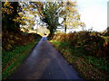
1
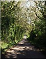
Lane to Birchill
A similar view to Image, showing the lane is summer.
Image: © Derek Harper
Taken: 16 May 2013
0.04 miles
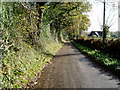
2
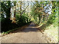
Road between Holy City and Birchill (2)
At Fernham looking in the direction of Holy City.
Image: © Peter Holmes
Taken: 20 Nov 2009
0.04 miles
3
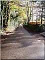
Road between Holy City and Birchill (3)
Near Parks Cottage looking in direction of Birchill.
Image: © Peter Holmes
Taken: 20 Nov 2009
0.05 miles
4
Start of Public Bridleway to Churchill
Image: © Peter Holmes
Taken: 20 Nov 2009
0.06 miles
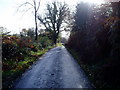
5
Road between Holy City and Birchill (1)
At Fernham looking in the direction of Birchill
Image: © Peter Holmes
Taken: 20 Nov 2009
0.09 miles
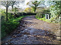
6

Lane to Birchill
From beneath a large oak tree. The lane takes several gentle left bends as it curves around The Parks, a former medieval deer park.
Image: © Derek Harper
Taken: 16 May 2013
0.09 miles
7
Road between Holy City and Birchill (4)
Near Beacon Hill looking in the direction of Birchill.
Image: © Peter Holmes
Taken: 20 Nov 2009
0.12 miles
8
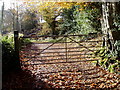
Track to Beaconhill Cottage
Gate on Public Bridleway.
Image: © Peter Holmes
Taken: 20 Nov 2009
0.13 miles
9
Road between Holy City and Birchill (5)
Approaching the track to Reads Hill Farm and looking in the direction of Holy City.
Image: © Peter Holmes
Taken: 20 Nov 2009
0.18 miles
10

Field west of The Parks
A view on the other side of the lane shown in Image] with the land sloping towards the River Kit valley. The wood on the right is in Image Chardstock Footpath 80 runs alongside the field boundary at the end of the field, heading across The Parks to Chardstock.
Image: © Derek Harper
Taken: 16 May 2013
0.25 miles