IMAGES TAKEN NEAR TO
Moorcox Cross, AXMINSTER, EX13 7EX
Introduction
This page details the photographs taken nearby to Moorcox Cross, EX13 7EX by members of the Geograph project.
The Geograph project started in 2005 with the aim of publishing, organising and preserving representative images for every square kilometre of Great Britain, Ireland and the Isle of Man.

There are currently over 7.5m images from over14,400 individuals and you can help contribute to the project by visiting https://www.geograph.org.uk
Image Map
Images are licensed for reuse under creativecommons.org/licenses/by-sa/2.0
Notes
- Clicking on the map will re-center to the selected point.
- The higher the marker number, the further away the image location is from the centre of the postcode.
Image Listing (8 Images Found)
Images are licensed for reuse under creativecommons.org/licenses/by-sa/2.0
Image
Details
Distance

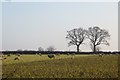
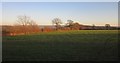
2

Field off Worham's Lane
Sloping off a greensand plateau. The railway and A35 run along the bottom of the hill.
Image: © Richard Webb
Taken: 9 Apr 2015
0.10 miles
4
Sheep on Kale
End of the Winter fodder off Worham's Lane.
Image: © Richard Webb
Taken: 9 Apr 2015
0.17 miles
5
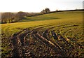
Field by Larkshayes Cross
Muddy ruts lead into a grass field by the Stockland Hill road. The land drops to the left into the Umborne Brook valley.
Image: © Derek Harper
Taken: 5 Dec 2012
0.18 miles
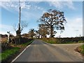
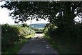
6
Road at Larkshayes Cross
The road across Larkshayes Knap seen from close to the junction with the Stockland Hill road.
Image: © Derek Harper
Taken: 5 Dec 2012
0.20 miles
7
Dalwood: towards Larkshayes Cross
Looking south west to the junction with the Stockland Hill road. The Umborne valley lies beyond
Image: © Martin Bodman
Taken: 26 Aug 2006
0.20 miles
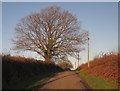
8
On Larkshayes Knap
Later afternoon sunlight on the plateau top. behind the sunlit hedge on the left runs Larkshayes Droveway and Dalwood Bridleway 7.
Image: © Derek Harper
Taken: 5 Dec 2012
0.22 miles