IMAGES TAKEN NEAR TO
Dalwood, AXMINSTER, EX13 7EU
Introduction
This page details the photographs taken nearby to EX13 7EU by members of the Geograph project.
The Geograph project started in 2005 with the aim of publishing, organising and preserving representative images for every square kilometre of Great Britain, Ireland and the Isle of Man.

There are currently over 7.5m images from over14,400 individuals and you can help contribute to the project by visiting https://www.geograph.org.uk
Image Map
Images are licensed for reuse under creativecommons.org/licenses/by-sa/2.0
Notes
- Clicking on the map will re-center to the selected point.
- The higher the marker number, the further away the image location is from the centre of the postcode.
Image Listing (7 Images Found)
Images are licensed for reuse under creativecommons.org/licenses/by-sa/2.0
Image
Details
Distance
1
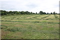
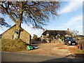
Drying Hay at Higher Way
This field of drying hay is on Dalwood Hill and the farm buildings of Higher Way can be seen in the right distance.
Image: © Nigel Mykura
Taken: 13 Jul 2019
0.17 miles
3
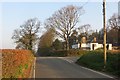
Worham's Lane
A busy yellow road running over a greensand plateau. View north from Burrow Corner.
Image: © Richard Webb
Taken: 9 Apr 2015
0.18 miles
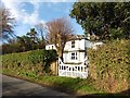
4
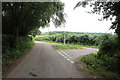
Burrow Corner
Burrow Knap Road turns off to the right from the road leading to Stockland Hill.
Image: © Derek Harper
Taken: 28 Aug 2012
0.21 miles
6
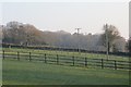
Fields, Dalwood
A field has been divided up with post and rail fencing.
Image: © Richard Webb
Taken: 9 Apr 2015
0.24 miles
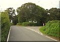
7
Gore on Dalwood Hill
This small gore is where Burrow Knap meets a minor road running down to Dalwood
Image: © Nigel Mykura
Taken: 13 Jul 2019
0.25 miles