IMAGES TAKEN NEAR TO
Dalwood, AXMINSTER, EX13 7DZ
Introduction
This page details the photographs taken nearby to EX13 7DZ by members of the Geograph project.
The Geograph project started in 2005 with the aim of publishing, organising and preserving representative images for every square kilometre of Great Britain, Ireland and the Isle of Man.

There are currently over 7.5m images from over14,400 individuals and you can help contribute to the project by visiting https://www.geograph.org.uk
Image Map
Images are licensed for reuse under creativecommons.org/licenses/by-sa/2.0
Notes
- Clicking on the map will re-center to the selected point.
- The higher the marker number, the further away the image location is from the centre of the postcode.
Image Listing (7 Images Found)
Images are licensed for reuse under creativecommons.org/licenses/by-sa/2.0
Image
Details
Distance
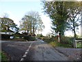
1

Road Junction. Lea, Devon
There was a lot of road works in this area when the photo was taken.
Image: © Stuart Buchan
Taken: 8 May 2006
0.05 miles
3
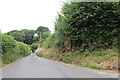
Sheppard's Knap
This is the top end of Seppard's Knap where it has a junction with the top of Burrow Knap.
Image: © Nigel Mykura
Taken: 13 Jul 2019
0.07 miles


6
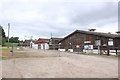
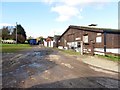
Farm Buildings near Anbank
This range of wooden farm buildings is on a tight curve in the Studhayes Rd.
Image: © Nigel Mykura
Taken: 13 Jul 2019
0.21 miles