IMAGES TAKEN NEAR TO
Lower Lane, AXMINSTER, EX13 7DW
Introduction
This page details the photographs taken nearby to Lower Lane, EX13 7DW by members of the Geograph project.
The Geograph project started in 2005 with the aim of publishing, organising and preserving representative images for every square kilometre of Great Britain, Ireland and the Isle of Man.

There are currently over 7.5m images from over14,400 individuals and you can help contribute to the project by visiting https://www.geograph.org.uk
Image Map
Images are licensed for reuse under creativecommons.org/licenses/by-sa/2.0
Notes
- Clicking on the map will re-center to the selected point.
- The higher the marker number, the further away the image location is from the centre of the postcode.
Image Listing (38 Images Found)
Images are licensed for reuse under creativecommons.org/licenses/by-sa/2.0
Image
Details
Distance
3

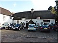
Dalwood: The Tuckers Arms
Reputedly 13th century, this inn predates the 15th century church of St Peter and is the oldest building in the village, which was once part of Dorset, but is now a Devon parish. The Tuckers Arms has its own entry in The Good Pub Guide, 2005. Note the old bread oven by the entrance, beyond the red car. Looking south east
Image: © Martin Bodman
Taken: 30 Apr 2006
0.10 miles
4
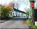
Dalwood community shop and post office
Image: © Roger Cornfoot
Taken: 8 Nov 2017
0.11 miles
5

Dalwood: church
Dedicated to St Peter and dating from the 15th century, it was remodelled in the Victorian era
Image: © Martin Bodman
Taken: 24 Jun 2004
0.11 miles
6
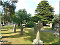
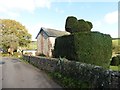
Two trees
St Peter's church, Dalwood.
The tree to the right is a majestic Yew. A Christian symbol of eternal life.
The left hand one is a Rowan or Mountain Ash. Folklore says that it will keep away witches. Accident or design?
Image: © Anthony Vosper
Taken: 5 Jul 2018
0.12 miles
7

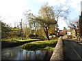
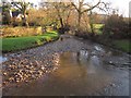
Dalwood Ford
This ford is found on the Corry Brook at Dalwood beside the road bridge.
Image: © John Walton
Taken: 5 Jun 2017
0.13 miles
8
Corry Brook
Image: © Derek Harper
Taken: 5 Dec 2012
0.13 miles
9
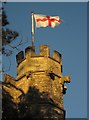
Church tower, Dalwood
The battlemented summit of the stair-turret on the tower of St Peter's church http://list.english-heritage.org.uk/resultsingle.aspx?uid=1170586&searchtype=mapsearch , with gargoyles and a St George flag.
Image: © Derek Harper
Taken: 5 Dec 2012
0.13 miles