IMAGES TAKEN NEAR TO
Chardstock, AXMINSTER, EX13 7DE
Introduction
This page details the photographs taken nearby to EX13 7DE by members of the Geograph project.
The Geograph project started in 2005 with the aim of publishing, organising and preserving representative images for every square kilometre of Great Britain, Ireland and the Isle of Man.

There are currently over 7.5m images from over14,400 individuals and you can help contribute to the project by visiting https://www.geograph.org.uk
Image Map
Images are licensed for reuse under creativecommons.org/licenses/by-sa/2.0
Notes
- Clicking on the map will re-center to the selected point.
- The higher the marker number, the further away the image location is from the centre of the postcode.
Image Listing (5 Images Found)
Images are licensed for reuse under creativecommons.org/licenses/by-sa/2.0
Image
Details
Distance
2
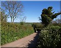
Huntley Lane
From the same point as Image], looking down the lane towards Hook. The strange-shaped ivy-clad tree can be seen in both images.
Image: © Derek Harper
Taken: 16 May 2013
0.06 miles
3
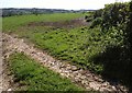
Field by Homeclose Lane
Another view across the field shown in Image Homeclose Lane is the former green lane that ran along the right side of the field, turning towards Hook Farm. Although some sections may still be used for farmers' field access, I don't think it's possible to follow it anymore, and the section on the right looks to be grown over.
Image: © Derek Harper
Taken: 16 May 2013
0.09 miles
4
Field by Huntley Lane
A view towards Chardstock.
Image: © Derek Harper
Taken: 16 May 2013
0.09 miles
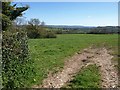
5

Cattle pasture, Huntley Lane
The field drops into the valley of a tributary of the Kit, surrounded by woodland.
Image: © Derek Harper
Taken: 16 May 2013
0.23 miles