IMAGES TAKEN NEAR TO
Chardstock, AXMINSTER, EX13 7BW
Introduction
This page details the photographs taken nearby to EX13 7BW by members of the Geograph project.
The Geograph project started in 2005 with the aim of publishing, organising and preserving representative images for every square kilometre of Great Britain, Ireland and the Isle of Man.

There are currently over 7.5m images from over14,400 individuals and you can help contribute to the project by visiting https://www.geograph.org.uk
Image Map
Images are licensed for reuse under creativecommons.org/licenses/by-sa/2.0
Notes
- Clicking on the map will re-center to the selected point.
- The higher the marker number, the further away the image location is from the centre of the postcode.
Image Listing (56 Images Found)
Images are licensed for reuse under creativecommons.org/licenses/by-sa/2.0
Image
Details
Distance

5
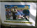
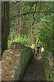
"Bless you for cleaning up after your dog"
By Chardstock Footpath 32 as it runs through the churchyard at Chardstock. The picture of St Francis is a somewhat blurred reproduction of Jean Fitzgerald's painting with added canines.
Image: © Derek Harper
Taken: 16 May 2013
0.12 miles

7
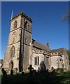
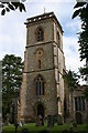
St Andrew's church, Chardstock
From the southwest corner of the churchyard; also shown in Image] and Image The church is described at http://list.english-heritage.org.uk/resultsingle.aspx?uid=1333540&searchtype=mapsearch .
Image: © Derek Harper
Taken: 16 May 2013
0.12 miles
8
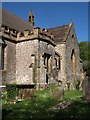
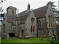
South side of St Andrew's church, Chardstock
Showing the part of the church that remains from the C15, including the embattled south porch; most of the church was rebuilt in 1864 http://list.english-heritage.org.uk/resultsingle.aspx?uid=1333540&searchtype=mapsearch . On the left is a listed tomb chest http://list.english-heritage.org.uk/resultsingle.aspx?uid=1169748&searchtype=mapsearch .
Image: © Derek Harper
Taken: 16 May 2013
0.12 miles
9
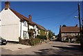
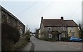
Village street, Chardstock
The longest of Chardstock's streets, eventually leading away to Tytherleigh, with the junction of the lane to Birchill on the right.
Image: © Derek Harper
Taken: 16 May 2013
0.12 miles